 Bel-Ha
San Jose El Alto
El Porvenir
Nueva Palestina
Santa Lucía
Chemax
La Morita
Temoac
Zacualpan
Bel-Ha
San Jose El Alto
El Porvenir
Nueva Palestina
Santa Lucía
Chemax
La Morita
Temoac
Zacualpan
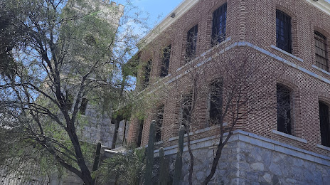
Museo Regional de Sonora on the map, Hermosillo, Mexico
Photo
Where is located Museo Regional de Sonora
Museo Regional de Sonora — local attraction, which is located at Jesús García Final s/n, La Matanza, 83080 Hermosillo, Son., Mexico and belongs to the category — museum. Average visitor rating for this place — 4.2 (according to 184 ratings, information from open sources and relevant for 2022).
Exact location — Museo Regional de Sonora, marked on the map with a red marker.
You can get directions to Museo Regional de Sonora on the map from your location.
What else is interesting in Hermosillo? You can see all the sights if you go to the city page.
Coordinates
Museo Regional de Sonora, Mexico coordinates in decimal format: latitude — 29.07486664433939, longitude — -110.9483699926732. When converted to degrees, minutes, seconds Museo Regional de Sonora has the following coordinates: 29°4′29.52 north latitude and -110°56′54.13 east longitude.
Nearby cities
The largest cities that are located nearby:
- Guaymas — 128 km
- Ciudad Obregón — 203 km
- Nogales
 (United States) — 251 km
 - Navojoa — 267 km
- Tucson (United States) — 348 km
- Los Mochis — 413 km
- Chandler (United States) — 475 km
- Chihuahua — 477 km
- Gilbert (United States) — 479 km
- Mesa (United States) — 487 km
- Tempe (United States) — 490 km
- Phoenix (United States) — 495 km
- Scottsdale (United States) — 497 km
- Glendale (United States) — 507 km
- Peoria (United States) — 512 km
- Ciudad Juarez — 515 km
- San Luis Río Colorado — 516 km
- El Paso (United States) — 519 km
- Delicias — 543 km
Distance to the capital
Distance to the capital (Mexico City) is about — 1606 km.