
 Manuel María Caballero
Santa Cruz Department
Pozo del Tigre
Motacucito
Colquiri
Inquisivi
Provincia de Andrés Ibáñez
Yacuíba
Tarija
Manuel María Caballero
Santa Cruz Department
Pozo del Tigre
Motacucito
Colquiri
Inquisivi
Provincia de Andrés Ibáñez
Yacuíba
Tarija
Prehistorico Sacaba Park on the map, Cochabamba, Bolivia
Photo
Where is located Prehistorico Sacaba Park
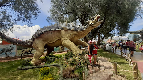
Prehistorico Sacaba Park — local attraction, which is located at JW3W+9WP, Sacaba, Bolivia and belongs to the category — park. Average visitor rating for this place — 4.0 (according to 1963 ratings, information from open sources and relevant for 2022).
Exact location — Prehistorico Sacaba Park, marked on the map with a red marker.
You can get directions to Prehistorico Sacaba Park on the map from your location.
What else is interesting in Cochabamba? You can see all the sights if you go to the city page.
Coordinates
Prehistorico Sacaba Park, Bolivia coordinates in decimal format: latitude — -17.396597754635547, longitude — -66.05286809288938. When converted to degrees, minutes, seconds Prehistorico Sacaba Park has the following coordinates: -17°23′47.75 north latitude and -66°3′10.33 east longitude.
Nearby cities
The largest cities that are located nearby:
- Oruro — 119 km
- Sucre — 204 km
- Potosi — 246 km
- Santa Cruz de la Sierra — 337 km
- Tacna
 (Peru) — 434 km
 - Fist (Peru) — 444 km
- Arica
 (Chile) — 451 km
 - Juliaca (Peru) — 471 km
- Tarija — 482 km
- Iquique (Chile) — 518 km
- Arequipa (Peru) — 580 km
- Calama (Chile) — 627 km
- Cusco (Peru) — 755 km
- San Salvador de Jujuy
 (Argentina) — 757 km
 - Antofagasta (Chile) — 815 km
- Salta (Argentina) — 822 km
- White River
 (Brazil) — 839 km
 - Ayacucho (Peru) — 985 km
- Porto Velho (Brazil) — 985 km
Distance to the capital
Distance to the capital (Nuestra Señora de La Paz) is about — 244 km.