 Bel-Ha
San Jose El Alto
El Porvenir
Nueva Palestina
Santa Lucía
Chemax
La Morita
Temoac
Zacualpan
Bel-Ha
San Jose El Alto
El Porvenir
Nueva Palestina
Santa Lucía
Chemax
La Morita
Temoac
Zacualpan
Centro Cultural Y Recreativo La Playita on the map, Reynosa, Mexico
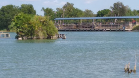
Photo
Where is located Centro Cultural Y Recreativo La Playita
Centro Cultural Y Recreativo La Playita — local attraction, which is located at 88614 Reynosa, Tamaulipas, Mexico and belongs to the category — city park. Average visitor rating for this place — 4.1 (according to 201 rating, information from open sources and relevant for 2022).
Exact location — Centro Cultural Y Recreativo La Playita, marked on the map with a red marker.
You can get directions to Centro Cultural Y Recreativo La Playita on the map from your location.
What else is interesting in Reynosa? You can see all the sights if you go to the city page.
Coordinates
Centro Cultural Y Recreativo La Playita, Mexico coordinates in decimal format: latitude — 26.14327226492401, longitude — -98.33350879273702. When converted to degrees, minutes, seconds Centro Cultural Y Recreativo La Playita has the following coordinates: 26°8′35.78 north latitude and -98°20′0.63 east longitude.
Nearby cities
The largest cities that are located nearby:
- McAllen
 (United States) — 13 km
 - Brownsville (United States) — 80 km
- Matamoros — 81 km
- Apodaca — 193 km
- Nuevo Laredo — 198 km
- Laredo (United States) — 198 km
- Guadalupe — 203 km
- San Nicolas de los Garza — 204 km
- General Escobedo — 206 km
- Corpus Christi (United States) — 208 km
- Monterrey — 208 km
- San Pedro Garza García — 217 km
- Santa Catarina — 223 km
- Ciudad Victoria — 275 km
- Saltillo — 281 km
- Monclova — 323 km
- Piedras Negras — 361 km
- San Antonio (United States) — 369 km
- Ciudad Madero — 427 km
Distance to the capital
Distance to the capital (Washington) is about — 2440 km.