
 Bel-Ha
San Jose El Alto
El Porvenir
Nueva Palestina
Santa Lucía
Chemax
La Morita
Temoac
Zacualpan
Bel-Ha
San Jose El Alto
El Porvenir
Nueva Palestina
Santa Lucía
Chemax
La Morita
Temoac
Zacualpan
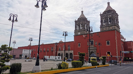
Temple of San Agustin on the map, Salamanca, Mexico
Photo
Where is located Temple of San Agustin
Temple of San Agustin — local attraction, which is located at Andrés Delgado, Centro, 36700 Salamanca, Gto., Mexico and belongs to the category — catholic church. Average visitor rating for this place — 4.6 (according to 491 rating, information from open sources and relevant for 2022).
Exact location — Temple of San Agustin, marked on the map with a red marker.
You can get directions to Temple of San Agustin on the map from your location.
What else is interesting in Salamanca? You can see all the sights if you go to the city page.
Coordinates
Temple of San Agustin, Mexico coordinates in decimal format: latitude — 20.56786777165434, longitude — -101.19859999284085. When converted to degrees, minutes, seconds Temple of San Agustin has the following coordinates: 20°34′4.32 north latitude and -101°11′54.96 east longitude.
Nearby cities
The largest cities that are located nearby:
- Irapuato — 20 km
- Celaya — 40 km
- León — 79 km
- Santiago de Querétaro — 84 km
- Morelia — 95 km
- San Juan del Río — 128 km
- Zamora — 129 km
- Uruapan — 156 km
- San Luis Potosi — 177 km
- Soledad de Graciano Sánchez — 181 km
- Aguascalientes — 184 km
- Tonalá — 211 km
- Toluca — 215 km
- Tlaquepaque — 219 km
- Metepec — 221 km
- Guadalajara — 223 km
- Cuautitlán Izcalli — 227 km
- Zapopan — 230 km
- Ciudad López Mateos — 230 km
Distance to the capital
Distance to the capital (Mexico City) is about — 250 km.