
 Bel-Ha
San Jose El Alto
El Porvenir
Nueva Palestina
Santa Lucía
Chemax
La Morita
Temoac
Zacualpan
Bel-Ha
San Jose El Alto
El Porvenir
Nueva Palestina
Santa Lucía
Chemax
La Morita
Temoac
Zacualpan
Jaguaroundi Ecological Park on the map, Coatzacoalcos, Mexico
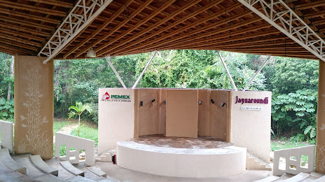
Photo
Where is located Jaguaroundi Ecological Park
Jaguaroundi Ecological Park — local attraction, which is located at Camino al Ejido Cangrejera Uno S/N, Coatzacoalcos, Ver., Mexico and belongs to the category — nature preserve. Average visitor rating for this place — 4.5 (according to 575 ratings, information from open sources and relevant for 2022).
Exact location — Jaguaroundi Ecological Park, marked on the map with a red marker.
You can get directions to Jaguaroundi Ecological Park on the map from your location.
What else is interesting in Coatzacoalcos? You can see all the sights if you go to the city page.
Coordinates
Jaguaroundi Ecological Park, Mexico coordinates in decimal format: latitude — 18.11130630677795, longitude — -94.35812049287912. When converted to degrees, minutes, seconds Jaguaroundi Ecological Park has the following coordinates: 18°6′40.7 north latitude and -94°21′29.23 east longitude.
Nearby cities
The largest cities that are located nearby:
- Minatitlán — 19 km
- Villahermosa — 160 km
- Tuxtla Gutiérrez — 210 km
- San Cristóbal de las Casas — 247 km
- Oaxaca — 267 km
- Córdoba — 271 km
- Ciudad del Carmen — 284 km
- Orizaba — 288 km
- Xalapa — 299 km
- Tehuacán — 311 km
- Martínez de la Torre — 344 km
- Puebla — 404 km
- Poza Rica de Hidalgo — 408 km
- Tapachula — 427 km
- Campeche — 449 km
- Tulancingo — 459 km
- Cuautla — 476 km
- Ixtapaluca — 479 km
- Chalco de Díaz Covarrubias — 480 km
Distance to the capital
Distance to the capital (Mexico City) is about — 524 km.