
 Bel-Ha
San Jose El Alto
El Porvenir
Nueva Palestina
Santa Lucía
Chemax
La Morita
Temoac
Zacualpan
Bel-Ha
San Jose El Alto
El Porvenir
Nueva Palestina
Santa Lucía
Chemax
La Morita
Temoac
Zacualpan
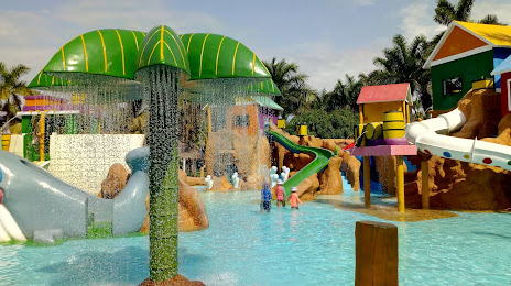
Parque Acuático Mazagua on the map, Mazatlán, Mexico
Photo
Where is located Parque Acuático Mazagua
Parque Acuático Mazagua — local attraction, which is located at Entronque, Av. Sábalo Cerritos, Sábalo Country, 82110 Mazatlán, Sin., Mexico and belongs to the category — water park. Average visitor rating for this place — 4.6 (according to 2872 ratings, information from open sources and relevant for 2022).
Exact location — Parque Acuático Mazagua, marked on the map with a red marker.
You can get directions to Parque Acuático Mazagua on the map from your location.
What else is interesting in Mazatlán? You can see all the sights if you go to the city page.
Coordinates
Parque Acuático Mazagua, Mexico coordinates in decimal format: latitude — 23.302515009110603, longitude — -106.48160569279284. When converted to degrees, minutes, seconds Parque Acuático Mazagua has the following coordinates: 23°18′9.05 north latitude and -106°28′53.78 east longitude.
Nearby cities
The largest cities that are located nearby:
- Durango — 197 km
- Tepic — 248 km
- Puerto Vallarta — 312 km
- Fresnillo — 360 km
- Los Mochis — 380 km
- Gómez Palacio — 390 km
- Torreón — 393 km
- Zacatecas — 394 km
- Matamoros — 405 km
- La Paz — 406 km
- Zapopan — 421 km
- Guadalajara — 427 km
- Tlaquepaque — 431 km
- Tonalá — 438 km
- Aguascalientes — 449 km
- Manzanillo — 506 km
- Navojoa — 518 km
- Colima — 524 km
- León — 541 km
Distance to the capital
Distance to the capital (Mexico City) is about — 874 km.