 Bel-Ha
San Jose El Alto
El Porvenir
Nueva Palestina
Santa Lucía
Chemax
La Morita
Temoac
Zacualpan
Bel-Ha
San Jose El Alto
El Porvenir
Nueva Palestina
Santa Lucía
Chemax
La Morita
Temoac
Zacualpan
Cerro del Topo Chico on the map, Apodaca, Mexico
Photo
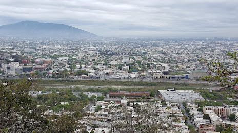
Where is located Cerro del Topo Chico
Cerro del Topo Chico — local attraction, which is located at 1,000 m and belongs to the category — -. Average visitor rating for this place — 4.6 (according to 34 ratings, information from open sources and relevant for 2022).
Exact location — Cerro del Topo Chico, marked on the map with a red marker.
You can get directions to Cerro del Topo Chico on the map from your location.
What else is interesting in Apodaca? You can see all the sights if you go to the city page.
Coordinates
Cerro del Topo Chico, Mexico coordinates in decimal format: latitude — 25.771799051965065, longitude — -100.16298379274467. When converted to degrees, minutes, seconds Cerro del Topo Chico has the following coordinates: 25°46′18.48 north latitude and -100°9′46.74 east longitude.
Nearby cities
The largest cities that are located nearby:
- San Nicolas de los Garza — 10 km
- General Escobedo — 13 km
- Guadalupe — 14 km
- Monterrey — 17 km
- San Pedro Garza García — 25 km
- Santa Catarina — 30 km
- Saltillo — 90 km
- Monclova — 174 km
- Reynosa — 193 km
- Nuevo Laredo — 198 km
- McAllen
 (United States) — 200 km
 - Laredo (United States) — 205 km
- Ciudad Victoria — 250 km
- Matamoros — 267 km
- Brownsville (United States) — 268 km
- Torreón — 322 km
- Piedras Negras — 324 km
- Gómez Palacio — 330 km
- Corpus Christi (United States) — 353 km
Distance to the capital
Distance to the capital (Mexico City) is about — 713 km.