
 Bel-Ha
San Jose El Alto
El Porvenir
Nueva Palestina
Santa Lucía
Chemax
La Morita
Temoac
Zacualpan
Bel-Ha
San Jose El Alto
El Porvenir
Nueva Palestina
Santa Lucía
Chemax
La Morita
Temoac
Zacualpan
Laguna Zapotlan on the map, Ciudad Guzmán, Mexico
Photo
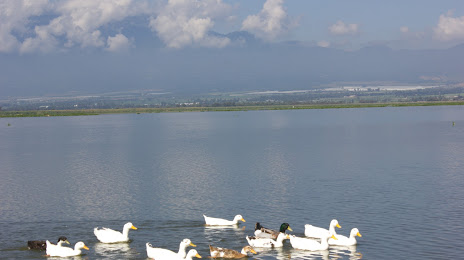
Where is located Laguna Zapotlan
Laguna Zapotlan — local attraction, which is located at no data and belongs to the category — -. Average visitor rating for this place — 4.0 (according to 270 ratings, information from open sources and relevant for 2022).
Exact location — Laguna Zapotlan, marked on the map with a red marker.
You can get directions to Laguna Zapotlan on the map from your location.
What else is interesting in Ciudad Guzmán? You can see all the sights if you go to the city page.
Coordinates
Laguna Zapotlan, Mexico coordinates in decimal format: latitude — 19.694252440011677, longitude — -103.51234047933586. When converted to degrees, minutes, seconds Laguna Zapotlan has the following coordinates: 19°41′39.31 north latitude and -103°30′44.43 east longitude.
Nearby cities
The largest cities that are located nearby:
- Colima — 57 km
- Tonalá — 105 km
- Tlaquepaque — 105 km
- Guadalajara — 107 km
- Zapopan — 108 km
- Manzanillo — 112 km
- Zamora — 127 km
- Uruapan — 152 km
- Puerto Vallarta — 210 km
- Morelia — 236 km
- León — 242 km
- Irapuato — 244 km
- Tepic — 248 km
- Salamanca — 253 km
- Aguascalientes — 270 km
- Celaya — 290 km
- Santiago de Querétaro — 333 km
- Zacatecas — 351 km
- San Juan del Río — 369 km
Distance to the capital
Distance to the capital (Mexico City) is about — 460 km.