
 Bel-Ha
San Jose El Alto
El Porvenir
Nueva Palestina
Santa Lucía
Chemax
La Morita
Temoac
Zacualpan
Bel-Ha
San Jose El Alto
El Porvenir
Nueva Palestina
Santa Lucía
Chemax
La Morita
Temoac
Zacualpan
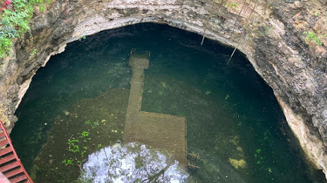
CENOTE CHICHIKAN on the map, Valladolid, Mexico
Photo
Where is located CENOTE CHICHIKAN
CENOTE CHICHIKAN — local attraction, which is located at KM 7 CDDTZM CHAN SACABA CARRETERA, 97784 Valladolid, Yuc., Mexico and belongs to the category — ecological park. Average visitor rating for this place — 4.7 (according to 37 ratings, information from open sources and relevant for 2022).
Exact location — CENOTE CHICHIKAN, marked on the map with a red marker.
You can get directions to CENOTE CHICHIKAN on the map from your location.
What else is interesting in Valladolid? You can see all the sights if you go to the city page.
Coordinates
CENOTE CHICHIKAN, Mexico coordinates in decimal format: latitude — 20.745456820093054, longitude — -88.20942620270561. When converted to degrees, minutes, seconds CENOTE CHICHIKAN has the following coordinates: 20°44′43.64 north latitude and -88°12′33.93 east longitude.
Nearby cities
The largest cities that are located nearby:
- Merida — 147 km
- Cancún — 149 km
- Chetumal — 242 km
- Campeche — 261 km
- Ciudad del Carmen — 440 km
- Pinar del Río
 (Cuba) — 501 km
 - La Ceiba
 (Honduras) — 563 km
 - Choloma (Honduras) — 564 km
- San Pedro Sula (Honduras) — 574 km
- Villahermosa — 581 km
- El Progreso (Honduras) — 586 km
- San Cristóbal de las Casas — 641 km
- Havana (Cuba) — 662 km
- Tuxtla Gutiérrez — 677 km
- San Juan Sacatepéquez
 (Guatemala) — 710 km
 - Coatzacoalcos — 716 km
- Guatemala City (Guatemala) — 717 km
- Matanzas (Cuba) — 726 km
- Villa Nueva (Guatemala) — 728 km
Distance to the capital
Distance to the capital (Mexico City) is about — 1150 km.