
 Bel-Ha
San Jose El Alto
El Porvenir
Nueva Palestina
Santa Lucía
Chemax
La Morita
Temoac
Zacualpan
Bel-Ha
San Jose El Alto
El Porvenir
Nueva Palestina
Santa Lucía
Chemax
La Morita
Temoac
Zacualpan
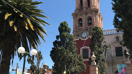
Parroquia de San Felipe Apóstol on the map, San Felipe, Mexico
Photo
Where is located Parroquia de San Felipe Apóstol
Parroquia de San Felipe Apóstol — local attraction, which is located at Juárez S/N, Centro, 37600 San Felipe, Gto., Mexico and belongs to the category — church. Average visitor rating for this place — 4.6 (according to 162 ratings, information from open sources and relevant for 2022).
Exact location — Parroquia de San Felipe Apóstol, marked on the map with a red marker.
You can get directions to Parroquia de San Felipe Apóstol on the map from your location.
What else is interesting in San Felipe? You can see all the sights if you go to the city page.
Coordinates
Parroquia de San Felipe Apóstol, Mexico coordinates in decimal format: latitude — 21.478285866830905, longitude — -101.21483350269324. When converted to degrees, minutes, seconds Parroquia de San Felipe Apóstol has the following coordinates: 21°28′41.83 north latitude and -101°12′53.4 east longitude.
Nearby cities
The largest cities that are located nearby:
- León — 62 km
- San Luis Potosi — 79 km
- Soledad de Graciano Sánchez — 83 km
- Irapuato — 90 km
- Salamanca — 101 km
- Celaya — 113 km
- Aguascalientes — 119 km
- Santiago de Querétaro — 130 km
- San Juan del Río — 176 km
- Morelia — 196 km
- Zamora — 198 km
- Zacatecas — 200 km
- Tonalá — 230 km
- Tlaquepaque — 236 km
- Guadalajara — 239 km
- Zapopan — 244 km
- Uruapan — 245 km
- Fresnillo — 252 km
- Cuautitlán Izcalli — 288 km
Distance to the capital
Distance to the capital (Mexico City) is about — 314 km.