
 Litoral Del Bajo San Juan
El Cantón de San Pablo
Juan Frío
Santa Barbara
El Juncal
Dibulla
Vereda Campo Alegre
San Pablo
Guaramito
Litoral Del Bajo San Juan
El Cantón de San Pablo
Juan Frío
Santa Barbara
El Juncal
Dibulla
Vereda Campo Alegre
San Pablo
Guaramito
Cerro de Quininí on the map, Fusagasuga, Colombia
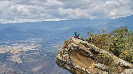
Photo
Where is located Cerro de Quininí
Cerro de Quininí — local attraction, which is located at 252230, Tibacuy, Cundinamarca, Colombia and belongs to the category — nature preserve. Average visitor rating for this place — 4.8 (according to 458 ratings, information from open sources and relevant for 2022).
Exact location — Cerro de Quininí, marked on the map with a red marker.
You can get directions to Cerro de Quininí on the map from your location.
What else is interesting in Fusagasuga? You can see all the sights if you go to the city page.
Coordinates
Cerro de Quininí, Colombia coordinates in decimal format: latitude — 4.3358306061981855, longitude — -74.48497490287245. When converted to degrees, minutes, seconds Cerro de Quininí has the following coordinates: 4°20′8.99 north latitude and -74°29′5.91 east longitude.
Nearby cities
The largest cities that are located nearby:
- Soacha — 31 km
- Girardot — 49 km
- Villavicencio — 84 km
- Ibagué — 97 km
- Armenia — 146 km
- Manizales — 150 km
- Dos Quebradas — 154 km
- Pereira — 156 km
- Tunja — 174 km
- Cartago — 177 km
- Neiva — 187 km
- Tuluá — 204 km
- Sogamoso — 219 km
- Buga — 219 km
- Palmira — 232 km
- Envigado — 243 km
- Itagüi — 244 km
- Medellín — 251 km
- Bello — 256 km
Distance to the capital
Distance to the capital (Bogota) is about — 54 km.