
 Bel-Ha
San Jose El Alto
El Porvenir
Nueva Palestina
Santa Lucía
Chemax
La Morita
Temoac
Zacualpan
Bel-Ha
San Jose El Alto
El Porvenir
Nueva Palestina
Santa Lucía
Chemax
La Morita
Temoac
Zacualpan
Playa Puerto Progreso on the map, Progreso, Mexico
Photo
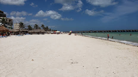
Where is located Playa Puerto Progreso
Playa Puerto Progreso — local attraction, which is located at no data and belongs to the category — -. Average visitor rating for this place — 4.6 (according to 473 ratings, information from open sources and relevant for 2022).
Exact location — Playa Puerto Progreso, marked on the map with a red marker.
You can get directions to Playa Puerto Progreso on the map from your location.
What else is interesting in Progreso? You can see all the sights if you go to the city page.
Coordinates
Playa Puerto Progreso, Mexico coordinates in decimal format: latitude — 21.27651114349034, longitude — -89.66700436211225. When converted to degrees, minutes, seconds Playa Puerto Progreso has the following coordinates: 21°16′35.44 north latitude and -89°40′1.22 east longitude.
Nearby cities
The largest cities that are located nearby:
- Merida — 35 km
- Campeche — 184 km
- Cancún — 290 km
- Chetumal — 339 km
- Ciudad del Carmen — 367 km
- Villahermosa — 502 km
- San Cristóbal de las Casas — 593 km
- Coatzacoalcos — 612 km
- Tuxtla Gutiérrez — 619 km
- Pinar del Río
 (Cuba) — 625 km
 - Minatitlán — 630 km
- Choloma
 (Honduras) — 655 km
 - San Pedro Sula (Honduras) — 662 km
- El Progreso (Honduras) — 680 km
- La Ceiba (Honduras) — 680 km
- San Juan Sacatepéquez
 (Guatemala) — 733 km
 - Quetzaltenango (Guatemala) — 740 km
- Guatemala City (Guatemala) — 743 km
- Villa Nueva (Guatemala) — 753 km
Distance to the capital
Distance to the capital (Mexico City) is about — 1008 km.