 Bel-Ha
San Jose El Alto
El Porvenir
Nueva Palestina
Santa Lucía
Chemax
La Morita
Temoac
Zacualpan
Bel-Ha
San Jose El Alto
El Porvenir
Nueva Palestina
Santa Lucía
Chemax
La Morita
Temoac
Zacualpan
Playa San Felipe on the map, San Felipe, Mexico
Photo
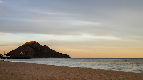
Where is located Playa San Felipe
Playa San Felipe — local attraction, which is located at no data and belongs to the category — -. Average visitor rating for this place — 4.8 (according to 47 ratings, information from open sources and relevant for 2022).
Exact location — Playa San Felipe, marked on the map with a red marker.
You can get directions to Playa San Felipe on the map from your location.
What else is interesting in San Felipe? You can see all the sights if you go to the city page.
Coordinates
Playa San Felipe, Mexico coordinates in decimal format: latitude — 31.006938718833663, longitude — -114.83456855960273. When converted to degrees, minutes, seconds Playa San Felipe has the following coordinates: 31°0′24.98 north latitude and -114°50′4.45 east longitude.
Nearby cities
The largest cities that are located nearby:
- San Luis Río Colorado — 158 km
- Mexicali — 186 km
- Ensenada — 190 km
- Tijuana — 263 km
- Chula Vista
 (United States) — 275 km
 - San Diego (United States) — 286 km
- Escondido (United States) — 311 km
- Oceanside (United States) — 336 km
- Phoenix (United States) — 370 km
- Glendale (United States) — 370 km
- Nogales (United States) — 371 km
- Peoria (United States) — 371 km
- Chandler (United States) — 375 km
- Tempe (United States) — 377 km
- Gilbert (United States) — 382 km
- Scottsdale (United States) — 383 km
- Mesa (United States) — 383 km
- Tucson (United States) — 389 km
- Moreno Valley (United States) — 390 km
Distance to the capital
Distance to the capital (Mexico City) is about — 2034 km.