
 Bel-Ha
San Jose El Alto
El Porvenir
Nueva Palestina
Santa Lucía
Chemax
La Morita
Temoac
Zacualpan
Bel-Ha
San Jose El Alto
El Porvenir
Nueva Palestina
Santa Lucía
Chemax
La Morita
Temoac
Zacualpan
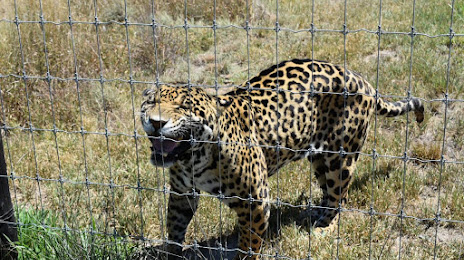
El Santuario del Jaguar on the map, Tlacolula de Matamoros, Mexico
Photo
Where is located El Santuario del Jaguar
El Santuario del Jaguar — local attraction, which is located at Carr. Internacional km 36. 5, San Isidro, 70400 Tlacolula de Matamoros, Oax., Mexico and belongs to the category — animal protection organization. Average visitor rating for this place — 4.5 (according to 182 ratings, information from open sources and relevant for 2022).
Exact location — El Santuario del Jaguar, marked on the map with a red marker.
You can get directions to El Santuario del Jaguar on the map from your location.
What else is interesting in Tlacolula de Matamoros? You can see all the sights if you go to the city page.
Coordinates
El Santuario del Jaguar, Mexico coordinates in decimal format: latitude — 16.936288170765017, longitude — -96.43595950276341. When converted to degrees, minutes, seconds El Santuario del Jaguar has the following coordinates: 16°56′10.64 north latitude and -96°26′9.45 east longitude.
Nearby cities
The largest cities that are located nearby:
- Oaxaca — 29 km
- Tehuacán — 193 km
- Córdoba — 218 km
- Orizaba — 220 km
- Minatitlán — 232 km
- Coatzacoalcos — 249 km
- Xalapa — 290 km
- Puebla — 293 km
- Chilpancingo — 326 km
- Cuautla — 331 km
- Martínez de la Torre — 349 km
- Jiutepec — 355 km
- Iguala — 357 km
- Tuxtla Gutiérrez — 358 km
- Chalco de Díaz Covarrubias — 359 km
- Cuernavaca — 361 km
- Acapulco — 361 km
- Ixtapaluca — 361 km
- Ciudad Nezahualcóyotl — 377 km
Distance to the capital
Distance to the capital (Mexico City) is about — 398 km.