
 Bel-Ha
San Jose El Alto
El Porvenir
Nueva Palestina
Santa Lucía
Chemax
La Morita
Temoac
Zacualpan
Bel-Ha
San Jose El Alto
El Porvenir
Nueva Palestina
Santa Lucía
Chemax
La Morita
Temoac
Zacualpan
Shrine of Christ the King (Santuario Votivo Nacional de Cristo Rey de la Paz) on the map, Marfil, Mexico
Photo
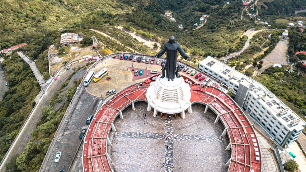
Where is located Shrine of Christ the King (Santuario Votivo Nacional de Cristo Rey de la Paz)
Shrine of Christ the King (Santuario Votivo Nacional de Cristo Rey de la Paz) — local attraction, which is located at Cerro del Cubilete S/N El Cubilete / la Montaña, 36290 Silao, Gto., Mexico and belongs to the category — shrine. Average visitor rating for this place — 4.7 (according to 1386 ratings, information from open sources and relevant for 2022).
Exact location — Shrine of Christ the King (Santuario Votivo Nacional de Cristo Rey de la Paz), marked on the map with a red marker.
You can get directions to Shrine of Christ the King (Santuario Votivo Nacional de Cristo Rey de la Paz) on the map from your location.
What else is interesting in Marfil? You can see all the sights if you go to the city page.
Coordinates
Shrine of Christ the King (Santuario Votivo Nacional de Cristo Rey de la Paz), Mexico coordinates in decimal format: latitude — 20.97266580474632, longitude — -101.29379507551891. When converted to degrees, minutes, seconds Shrine of Christ the King (Santuario Votivo Nacional de Cristo Rey de la Paz) has the following coordinates: 20°58′21.6 north latitude and -101°17′37.66 east longitude.
Nearby cities
The largest cities that are located nearby:
- Irapuato — 36 km
- León — 43 km
- Salamanca — 48 km
- Celaya — 72 km
- Santiago de Querétaro — 103 km
- San Luis Potosi — 132 km
- Soledad de Graciano Sánchez — 137 km
- Aguascalientes — 142 km
- Morelia — 143 km
- San Juan del Río — 151 km
- Zamora — 152 km
- Uruapan — 192 km
- Tonalá — 206 km
- Tlaquepaque — 213 km
- Guadalajara — 216 km
- Zapopan — 223 km
- Zacatecas — 237 km
- Toluca — 255 km
- Cuautitlán Izcalli — 259 km
Distance to the capital
Distance to the capital (Mexico City) is about — 283 km.