 Bel-Ha
San Jose El Alto
El Porvenir
Nueva Palestina
Santa Lucía
Chemax
La Morita
Temoac
Zacualpan
Bel-Ha
San Jose El Alto
El Porvenir
Nueva Palestina
Santa Lucía
Chemax
La Morita
Temoac
Zacualpan
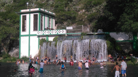
El Ojo De Agua Park (Parque El Ojo De Agua) on the map, Sabinas Hidalgo, Mexico
Photo
Where is located El Ojo De Agua Park (Parque El Ojo De Agua)
El Ojo De Agua Park (Parque El Ojo De Agua) — local attraction, which is located at a Km, Villa Aldama 4, San Jerónimo Lídice, N.L., Mexico and belongs to the category — park. Average visitor rating for this place — 4.6 (according to 684 ratings, information from open sources and relevant for 2022).
Exact location — El Ojo De Agua Park (Parque El Ojo De Agua), marked on the map with a red marker.
You can get directions to El Ojo De Agua Park (Parque El Ojo De Agua) on the map from your location.
What else is interesting in Sabinas Hidalgo? You can see all the sights if you go to the city page.
Coordinates
El Ojo De Agua Park (Parque El Ojo De Agua), Mexico coordinates in decimal format: latitude — 26.485613470696354, longitude — -100.22305797541468. When converted to degrees, minutes, seconds El Ojo De Agua Park (Parque El Ojo De Agua) has the following coordinates: 26°29′8.21 north latitude and -100°13′23.01 east longitude.
Nearby cities
The largest cities that are located nearby:
- Apodaca — 79 km
- General Escobedo — 81 km
- San Nicolas de los Garza — 84 km
- Monterrey — 91 km
- Guadalupe — 91 km
- San Pedro Garza García — 96 km
- Santa Catarina — 96 km
- Nuevo Laredo — 125 km
- Monclova — 130 km
- Laredo
 (United States) — 133 km
 - Saltillo — 144 km
- Reynosa — 194 km
- McAllen (United States) — 196 km
- Piedras Negras — 245 km
- Brownsville (United States) — 275 km
- Matamoros — 276 km
- Corpus Christi (United States) — 308 km
- Ciudad Acuna — 321 km
- Ciudad Victoria — 323 km
Distance to the capital
Distance to the capital (Mexico City) is about — 792 km.