
 Bel-Ha
San Jose El Alto
El Porvenir
Nueva Palestina
Santa Lucía
Chemax
La Morita
Temoac
Zacualpan
Bel-Ha
San Jose El Alto
El Porvenir
Nueva Palestina
Santa Lucía
Chemax
La Morita
Temoac
Zacualpan
Israel C. Tellez Park (Parque Israel C. Tellez) on the map, Papantla, Mexico
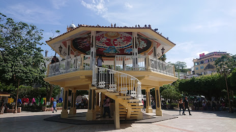
Photo
Where is located Israel C. Tellez Park (Parque Israel C. Tellez)
Israel C. Tellez Park (Parque Israel C. Tellez) — local attraction, which is located at 93400, Heroico Colegio Militar 303, Barrio del Naranjo, 93400 Papantla de Olarte, Ver., Mexico and belongs to the category — park. Average visitor rating for this place — 4.5 (according to 684 ratings, information from open sources and relevant for 2022).
Exact location — Israel C. Tellez Park (Parque Israel C. Tellez), marked on the map with a red marker.
You can get directions to Israel C. Tellez Park (Parque Israel C. Tellez) on the map from your location.
What else is interesting in Papantla? You can see all the sights if you go to the city page.
Coordinates
Israel C. Tellez Park (Parque Israel C. Tellez), Mexico coordinates in decimal format: latitude — 20.44657984826898, longitude — -97.32214597552765. When converted to degrees, minutes, seconds Israel C. Tellez Park (Parque Israel C. Tellez) has the following coordinates: 20°26′47.69 north latitude and -97°19′19.73 east longitude.
Nearby cities
The largest cities that are located nearby:
- Poza Rica de Hidalgo — 17 km
- Martínez de la Torre — 51 km
- Xalapa — 109 km
- Tulancingo — 117 km
- Tantoyuca — 136 km
- Pachuca — 155 km
- Córdoba — 179 km
- Orizaba — 179 km
- Puebla — 182 km
- Texcoco — 194 km
- Ojo de Agua — 198 km
- Ecatepec — 204 km
- Tampico — 204 km
- Ciudad Madero — 205 km
- Chimalhuacan — 205 km
- Ixtapaluca — 207 km
- Coacalco — 208 km
- Ciudad Nezahualcóyotl — 210 km
- Chalco de Díaz Covarrubias — 211 km
Distance to the capital
Distance to the capital (Mexico City) is about — 220 km.