
 Bel-Ha
San Jose El Alto
El Porvenir
Nueva Palestina
Santa Lucía
Chemax
La Morita
Temoac
Zacualpan
Bel-Ha
San Jose El Alto
El Porvenir
Nueva Palestina
Santa Lucía
Chemax
La Morita
Temoac
Zacualpan
Te-Pathé on the map, Ixmiquilpan, Mexico
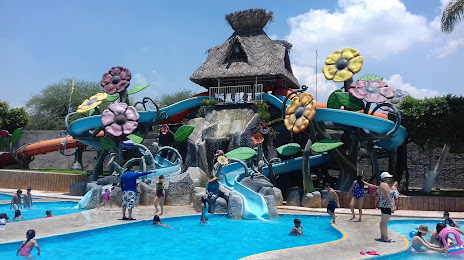
Photo
Where is located Te-Pathé
Te-Pathé — local attraction, which is located at Carretera México-Laredo Km.152.5 Colonia, 42300 El Tephé, Hgo., Mexico and belongs to the category — water park. Average visitor rating for this place — 4.4 (according to 12859 ratings, information from open sources and relevant for 2022).
Exact location — Te-Pathé, marked on the map with a red marker.
You can get directions to Te-Pathé on the map from your location.
What else is interesting in Ixmiquilpan? You can see all the sights if you go to the city page.
Coordinates
Te-Pathé, Mexico coordinates in decimal format: latitude — 20.44644524822937, longitude — -99.16800317552762. When converted to degrees, minutes, seconds Te-Pathé has the following coordinates: 20°26′47.2 north latitude and -99°10′4.81 east longitude.
Nearby cities
The largest cities that are located nearby:
- Pachuca — 64 km
- San Juan del Río — 80 km
- Ojo de Agua — 91 km
- Cuautitlán Izcalli — 92 km
- Coacalco — 95 km
- Buenavista — 97 km
- Tulancingo — 99 km
- Ecatepec — 99 km
- Ciudad López Mateos — 103 km
- Tlalnepantla — 105 km
- Naucalpan — 111 km
- Texcoco — 113 km
- Chimalhuacan — 119 km
- Santiago de Querétaro — 122 km
- Ciudad Nezahualcóyotl — 122 km
- Ixtapaluca — 135 km
- Chalco de Díaz Covarrubias — 139 km
- Tantoyuca — 140 km
- Toluca — 140 km
Distance to the capital
Distance to the capital (Mexico City) is about — 113 km.