
 Bel-Ha
San Jose El Alto
El Porvenir
Nueva Palestina
Santa Lucía
Chemax
La Morita
Temoac
Zacualpan
Bel-Ha
San Jose El Alto
El Porvenir
Nueva Palestina
Santa Lucía
Chemax
La Morita
Temoac
Zacualpan
Site Museum Comalcalco on the map, Comalcalco, Mexico
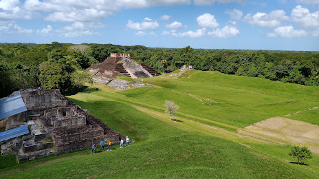
Photo
Where is located Site Museum Comalcalco
Site Museum Comalcalco — local attraction, which is located at Zona Arqueológica de, 86900 Comalcalco, Tab., Mexico and belongs to the category — museum. Average visitor rating for this place — 4.6 (according to 1516 ratings, information from open sources and relevant for 2022).
Exact location — Site Museum Comalcalco, marked on the map with a red marker.
You can get directions to Site Museum Comalcalco on the map from your location.
What else is interesting in Comalcalco? You can see all the sights if you go to the city page.
Coordinates
Site Museum Comalcalco, Mexico coordinates in decimal format: latitude — 18.28049404436153, longitude — -93.20523577556139. When converted to degrees, minutes, seconds Site Museum Comalcalco has the following coordinates: 18°16′49.78 north latitude and -93°12′18.85 east longitude.
Nearby cities
The largest cities that are located nearby:
- Villahermosa — 42 km
- Coatzacoalcos — 131 km
- Minatitlán — 143 km
- Ciudad del Carmen — 154 km
- Tuxtla Gutiérrez — 167 km
- San Cristóbal de las Casas — 180 km
- Campeche — 329 km
- Tapachula — 385 km
- Oaxaca — 393 km
- Córdoba — 393 km
- Xalapa — 410 km
- Orizaba — 411 km
- Quetzaltenango
 (Guatemala) — 421 km
 - Tehuacán — 439 km
- Martínez de la Torre — 445 km
- San Juan Sacatepéquez (Guatemala) — 479 km
- Merida — 479 km
- Guatemala City (Guatemala) — 495 km
- Villa Nueva (Guatemala) — 500 km
Distance to the capital
Distance to the capital (Mexico City) is about — 637 km.