
 Bel-Ha
San Jose El Alto
El Porvenir
Nueva Palestina
Santa Lucía
Chemax
La Morita
Temoac
Zacualpan
Bel-Ha
San Jose El Alto
El Porvenir
Nueva Palestina
Santa Lucía
Chemax
La Morita
Temoac
Zacualpan
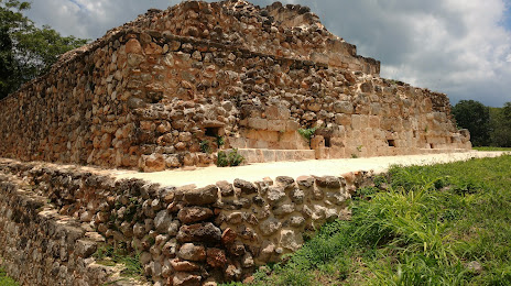
Oxkintoc Archaeological Zone on the map, Maxcanú, Mexico
Photo
Where is located Oxkintoc Archaeological Zone
Oxkintoc Archaeological Zone — local attraction, which is located at 97802 Maxcanú, Yucatan, Mexico and belongs to the category — archaeological site. Average visitor rating for this place — 4.7 (according to 214 ratings, information from open sources and relevant for 2022).
Exact location — Oxkintoc Archaeological Zone, marked on the map with a red marker.
You can get directions to Oxkintoc Archaeological Zone on the map from your location.
What else is interesting in Maxcanú? You can see all the sights if you go to the city page.
Coordinates
Oxkintoc Archaeological Zone, Mexico coordinates in decimal format: latitude — 20.561717082189006, longitude — -89.95324807552574. When converted to degrees, minutes, seconds Oxkintoc Archaeological Zone has the following coordinates: 20°33′42.18 north latitude and -89°57′11.69 east longitude.
Nearby cities
The largest cities that are located nearby:
- Merida — 59 km
- Campeche — 101 km
- Ciudad del Carmen — 287 km
- Chetumal — 290 km
- Cancún — 329 km
- Villahermosa — 424 km
- San Cristóbal de las Casas — 510 km
- Tuxtla Gutiérrez — 537 km
- Coatzacoalcos — 543 km
- Minatitlán — 560 km
- Choloma
 (Honduras) — 593 km
 - San Pedro Sula (Honduras) — 599 km
- El Progreso (Honduras) — 619 km
- La Ceiba (Honduras) — 629 km
- San Juan Sacatepéquez
 (Guatemala) — 652 km
 - Quetzaltenango (Guatemala) — 656 km
- Guatemala City (Guatemala) — 663 km
- Villa Nueva (Guatemala) — 673 km
- Tapachula — 673 km
Distance to the capital
Distance to the capital (Mexico City) is about — 968 km.