
 Bel-Ha
San Jose El Alto
El Porvenir
Nueva Palestina
Santa Lucía
Chemax
La Morita
Temoac
Zacualpan
Bel-Ha
San Jose El Alto
El Porvenir
Nueva Palestina
Santa Lucía
Chemax
La Morita
Temoac
Zacualpan
Villas Malinali on the map, Compostela, Mexico
Photo
Where is located Villas Malinali
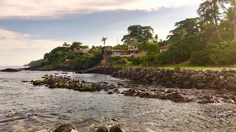
Villas Malinali — local attraction, which is located at cto oceano, Pacifico, Chacala, Nay., Mexico and belongs to the category — public beach. Average visitor rating for this place — 4.4 (according to 21 rating, information from open sources and relevant for 2022).
Exact location — Villas Malinali, marked on the map with a red marker.
You can get directions to Villas Malinali on the map from your location.
What else is interesting in Compostela? You can see all the sights if you go to the city page.
Coordinates
Villas Malinali, Mexico coordinates in decimal format: latitude — 21.165653498067336, longitude — -105.22765390605042. When converted to degrees, minutes, seconds Villas Malinali has the following coordinates: 21°9′56.35 north latitude and -105°13′39.55 east longitude.
Nearby cities
The largest cities that are located nearby:
- Tepic — 29 km
- Puerto Vallarta — 73 km
- Zapopan — 166 km
- Guadalajara — 173 km
- Tlaquepaque — 177 km
- Tonalá — 185 km
- Manzanillo — 242 km
- Colima — 252 km
- Mazatlán — 270 km
- Aguascalientes — 277 km
- Zacatecas — 291 km
- Fresnillo — 298 km
- Zamora — 305 km
- Durango — 309 km
- León — 332 km
- Uruapan — 360 km
- Irapuato — 372 km
- Salamanca — 390 km
- San Luis Potosi — 414 km
Distance to the capital
Distance to the capital (Mexico City) is about — 664 km.