
 Bel-Ha
San Jose El Alto
El Porvenir
Nueva Palestina
Santa Lucía
Chemax
La Morita
Temoac
Zacualpan
Bel-Ha
San Jose El Alto
El Porvenir
Nueva Palestina
Santa Lucía
Chemax
La Morita
Temoac
Zacualpan
BOSQUE CUAUHTÉMOC on the map, Jiquilpan, Mexico
Photo
Where is located BOSQUE CUAUHTÉMOC
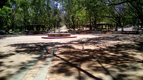
BOSQUE CUAUHTÉMOC — local attraction, which is located at Calz. del Bosque, Col Cuauhtémoc, 59510 Jiquilpan de Juárez, Mich., Mexico and belongs to the category — park. Average visitor rating for this place — 4.5 (according to 835 ratings, information from open sources and relevant for 2022).
Exact location — BOSQUE CUAUHTÉMOC, marked on the map with a red marker.
You can get directions to BOSQUE CUAUHTÉMOC on the map from your location.
What else is interesting in Jiquilpan? You can see all the sights if you go to the city page.
Coordinates
BOSQUE CUAUHTÉMOC, Mexico coordinates in decimal format: latitude — 19.98317081359687, longitude — -102.72004027553515. When converted to degrees, minutes, seconds BOSQUE CUAUHTÉMOC has the following coordinates: 19°58′59.41 north latitude and -102°43′12.14 east longitude.
Nearby cities
The largest cities that are located nearby:
- Zamora — 45 km
- Tonalá — 88 km
- Tlaquepaque — 94 km
- Uruapan — 96 km
- Guadalajara — 98 km
- Zapopan — 104 km
- Colima — 133 km
- Irapuato — 160 km
- Morelia — 162 km
- León — 165 km
- Salamanca — 170 km
- Manzanillo — 195 km
- Celaya — 206 km
- Aguascalientes — 214 km
- Santiago de Querétaro — 250 km
- Puerto Vallarta — 269 km
- Tepic — 279 km
- San Juan del Río — 287 km
- San Luis Potosi — 298 km
Distance to the capital
Distance to the capital (Mexico City) is about — 381 km.