 Bel-Ha
San Jose El Alto
El Porvenir
Nueva Palestina
Santa Lucía
Chemax
La Morita
Temoac
Zacualpan
Bel-Ha
San Jose El Alto
El Porvenir
Nueva Palestina
Santa Lucía
Chemax
La Morita
Temoac
Zacualpan
Playa El Cochorit on the map, Empalme, Mexico
Photo
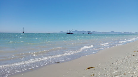
Where is located Playa El Cochorit
Playa El Cochorit — local attraction, which is located at Al Cochórit, 85520 Empalme, Son., Mexico and belongs to the category — tourist attraction. Average visitor rating for this place — 4.3 (according to 586 ratings, information from open sources and relevant for 2022).
Exact location — Playa El Cochorit, marked on the map with a red marker.
You can get directions to Playa El Cochorit on the map from your location.
What else is interesting in Empalme? You can see all the sights if you go to the city page.
Coordinates
Playa El Cochorit, Mexico coordinates in decimal format: latitude — 27.924515352116774, longitude — -110.90605142739618. When converted to degrees, minutes, seconds Playa El Cochorit has the following coordinates: 27°55′28.26 north latitude and -110°54′21.79 east longitude.
Nearby cities
The largest cities that are located nearby:
- Guaymas — 10 km
- Ciudad Obregón — 101 km
- Hermosillo — 124 km
- Navojoa — 167 km
- Los Mochis — 301 km
- Nogales
 (United States) — 374 km
 - La Paz — 425 km
- Chihuahua — 466 km
- Tucson (United States) — 471 km
- Delicias — 521 km
- Ciudad Juarez — 583 km
- El Paso (United States) — 589 km
- Chandler (United States) — 598 km
- Gilbert (United States) — 603 km
- Mesa (United States) — 610 km
- Tempe (United States) — 613 km
- Phoenix (United States) — 618 km
- San Luis Río Colorado — 619 km
- Scottsdale (United States) — 620 km
Distance to the capital
Distance to the capital (Mexico City) is about — 1525 km.