
 Bel-Ha
San Jose El Alto
El Porvenir
Nueva Palestina
Santa Lucía
Chemax
La Morita
Temoac
Zacualpan
Bel-Ha
San Jose El Alto
El Porvenir
Nueva Palestina
Santa Lucía
Chemax
La Morita
Temoac
Zacualpan
The Convent of Yuriria on the map, Yuriria, Mexico
Photo
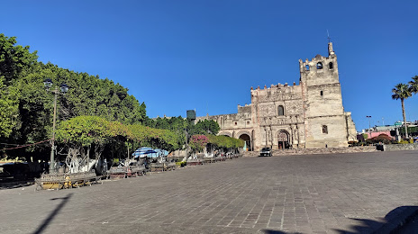
Where is located The Convent of Yuriria
The Convent of Yuriria — local attraction, which is located at Antiguo del Tareta, 38940 Yuriria, Guanajuato, Mexico and belongs to the category — historical landmark. Average visitor rating for this place — 4.0 (according to 4 ratings, information from open sources and relevant for 2022).
Exact location — The Convent of Yuriria, marked on the map with a red marker.
You can get directions to The Convent of Yuriria on the map from your location.
What else is interesting in Yuriria? You can see all the sights if you go to the city page.
Coordinates
The Convent of Yuriria, Mexico coordinates in decimal format: latitude — 20.213629480199916, longitude — -101.13099607553143. When converted to degrees, minutes, seconds The Convent of Yuriria has the following coordinates: 20°12′49.07 north latitude and -101°7′51.59 east longitude.
Nearby cities
The largest cities that are located nearby:
- Salamanca — 40 km
- Celaya — 48 km
- Morelia — 56 km
- Irapuato — 57 km
- Santiago de Querétaro — 87 km
- León — 116 km
- San Juan del Río — 120 km
- Zamora — 122 km
- Uruapan — 130 km
- Toluca — 185 km
- Metepec — 192 km
- Cuautitlán Izcalli — 205 km
- Ciudad López Mateos — 207 km
- Naucalpan — 214 km
- Buenavista — 215 km
- Tlalnepantla — 216 km
- San Luis Potosi — 216 km
- Soledad de Graciano Sánchez — 219 km
- Aguascalientes — 220 km
Distance to the capital
Distance to the capital (Mexico City) is about — 226 km.