
 Bel-Ha
San Jose El Alto
El Porvenir
Nueva Palestina
Santa Lucía
Chemax
La Morita
Temoac
Zacualpan
Bel-Ha
San Jose El Alto
El Porvenir
Nueva Palestina
Santa Lucía
Chemax
La Morita
Temoac
Zacualpan
Monumento a Cristo Rey on the map, Tenancingo, Mexico
Photo
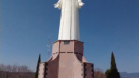
Where is located Monumento a Cristo Rey
Monumento a Cristo Rey — local attraction, which is located at 52400, Providencia, Tenancingo de Degollado, Méx., Mexico and belongs to the category — monument. Average visitor rating for this place — 4.7 (according to 1200 ratings, information from open sources and relevant for 2022).
Exact location — Monumento a Cristo Rey, marked on the map with a red marker.
You can get directions to Monumento a Cristo Rey on the map from your location.
What else is interesting in Tenancingo? You can see all the sights if you go to the city page.
Coordinates
Monumento a Cristo Rey, Mexico coordinates in decimal format: latitude — 18.96956942940229, longitude — -99.59462607555102. When converted to degrees, minutes, seconds Monumento a Cristo Rey has the following coordinates: 18°58′10.45 north latitude and -99°35′40.65 east longitude.
Nearby cities
The largest cities that are located nearby:
- Metepec — 32 km
- Toluca — 36 km
- Cuernavaca — 39 km
- Jiutepec — 44 km
- Iguala — 68 km
- Cuautla — 69 km
- Naucalpan — 69 km
- Ciudad López Mateos — 74 km
- Tlalnepantla — 76 km
- Ciudad Nezahualcóyotl — 79 km
- Chalco de Díaz Covarrubias — 80 km
- Buenavista — 83 km
- Ixtapaluca — 83 km
- Chimalhuacan — 84 km
- Cuautitlán Izcalli — 84 km
- Coacalco — 90 km
- Ecatepec — 90 km
- Texcoco — 95 km
- Ojo de Agua — 98 km
Distance to the capital
Distance to the capital (Mexico City) is about — 71 km.