 Bel-Ha
San Jose El Alto
El Porvenir
Nueva Palestina
Santa Lucía
Chemax
La Morita
Temoac
Zacualpan
Bel-Ha
San Jose El Alto
El Porvenir
Nueva Palestina
Santa Lucía
Chemax
La Morita
Temoac
Zacualpan
Las Palapas on the map, San Luis Río Colorado, Mexico
Photo
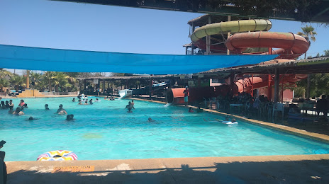
Where is located Las Palapas
Las Palapas — local attraction, which is located at C. 47, México, 83498 San Luis Río Colorado, Son., Mexico and belongs to the category — water park. Average visitor rating for this place — 4.3 (according to 344 ratings, information from open sources and relevant for 2022).
Exact location — Las Palapas, marked on the map with a red marker.
You can get directions to Las Palapas on the map from your location.
What else is interesting in San Luis Río Colorado? You can see all the sights if you go to the city page.
Coordinates
Las Palapas, Mexico coordinates in decimal format: latitude — 32.447992451072544, longitude — -114.74828257937698. When converted to degrees, minutes, seconds Las Palapas has the following coordinates: 32°26′52.77 north latitude and -114°44′53.82 east longitude.
Nearby cities
The largest cities that are located nearby:
- Mexicali — 66 km
- Ensenada — 184 km
- Tijuana — 211 km
- Chula Vista
 (United States) — 216 km
 - San Diego (United States) — 224 km
- Escondido (United States) — 227 km
- Oceanside (United States) — 255 km
- Peoria (United States) — 265 km
- Glendale (United States) — 267 km
- Phoenix (United States) — 272 km
- Moreno Valley (United States) — 279 km
- Tempe (United States) — 283 km
- Scottsdale (United States) — 287 km
- Chandler (United States) — 287 km
- Mesa (United States) — 292 km
- Riverside (United States) — 292 km
- Gilbert (United States) — 293 km
- San Bernardino (United States) — 294 km
- Rialto (United States) — 300 km
Distance to the capital
Distance to the capital (Mexico City) is about — 2125 km.