
 Bel-Ha
San Jose El Alto
El Porvenir
Nueva Palestina
Santa Lucía
Chemax
La Morita
Temoac
Zacualpan
Bel-Ha
San Jose El Alto
El Porvenir
Nueva Palestina
Santa Lucía
Chemax
La Morita
Temoac
Zacualpan
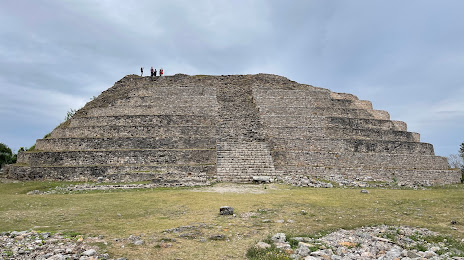
Pirámide de Itzamatul on the map, Izamal, Mexico
Photo
Where is located Pirámide de Itzamatul
Pirámide de Itzamatul — local attraction, which is located at C. 26 296, Centro, 97540 Izamal, Yuc., Mexico and belongs to the category — historical landmark. Average visitor rating for this place — 4.5 (according to 510 ratings, information from open sources and relevant for 2022).
Exact location — Pirámide de Itzamatul, marked on the map with a red marker.
You can get directions to Pirámide de Itzamatul on the map from your location.
What else is interesting in Izamal? You can see all the sights if you go to the city page.
Coordinates
Pirámide de Itzamatul, Mexico coordinates in decimal format: latitude — 20.933776993048838, longitude — -89.01570877551954. When converted to degrees, minutes, seconds Pirámide de Itzamatul has the following coordinates: 20°56′1.6 north latitude and -89°0′56.55 east longitude.
Nearby cities
The largest cities that are located nearby:
- Merida — 59 km
- Campeche — 199 km
- Cancún — 225 km
- Chetumal — 279 km
- Ciudad del Carmen — 386 km
- Villahermosa — 525 km
- Pinar del Río
 (Cuba) — 571 km
 - Choloma
 (Honduras) — 601 km
 - San Cristóbal de las Casas — 601 km
- San Pedro Sula (Honduras) — 610 km
- La Ceiba (Honduras) — 617 km
- El Progreso (Honduras) — 625 km
- Tuxtla Gutiérrez — 632 km
- Coatzacoalcos — 649 km
- Minatitlán — 666 km
- San Juan Sacatepéquez
 (Guatemala) — 708 km
 - Guatemala City (Guatemala) — 717 km
- Quetzaltenango (Guatemala) — 725 km
- Villa Nueva (Guatemala) — 727 km
Distance to the capital
Distance to the capital (Mexico City) is about — 1069 km.