
 Bel-Ha
San Jose El Alto
El Porvenir
Nueva Palestina
Santa Lucía
Chemax
La Morita
Temoac
Zacualpan
Bel-Ha
San Jose El Alto
El Porvenir
Nueva Palestina
Santa Lucía
Chemax
La Morita
Temoac
Zacualpan
Parroquia de Santa Ana on the map, Zacapu, Mexico
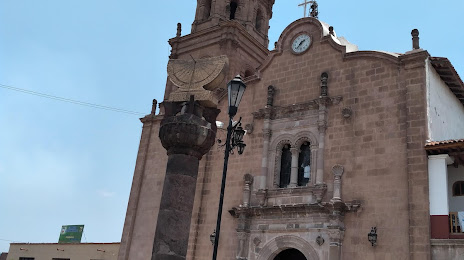
Photo
Where is located Parroquia de Santa Ana
Parroquia de Santa Ana — local attraction, which is located at C. de Zaragoza 103, Centro, 58600 Zacapu, Mich., Mexico and belongs to the category — catholic church. Average visitor rating for this place — 4.6 (according to 382 ratings, information from open sources and relevant for 2022).
Exact location — Parroquia de Santa Ana, marked on the map with a red marker.
You can get directions to Parroquia de Santa Ana on the map from your location.
What else is interesting in Zacapu? You can see all the sights if you go to the city page.
Coordinates
Parroquia de Santa Ana, Mexico coordinates in decimal format: latitude — 19.819293866683104, longitude — -101.7908107755378. When converted to degrees, minutes, seconds Parroquia de Santa Ana has the following coordinates: 19°49′9.46 north latitude and -101°47′26.92 east longitude.
Nearby cities
The largest cities that are located nearby:
- Uruapan — 52 km
- Zamora — 54 km
- Morelia — 64 km
- Salamanca — 104 km
- Irapuato — 106 km
- Celaya — 129 km
- León — 146 km
- Santiago de Querétaro — 169 km
- Tonalá — 174 km
- Tlaquepaque — 182 km
- Guadalajara — 186 km
- Zapopan — 193 km
- San Juan del Río — 198 km
- Colima — 211 km
- Toluca — 231 km
- Aguascalientes — 235 km
- Metepec — 238 km
- Ciudad López Mateos — 265 km
- Cuautitlán Izcalli — 266 km
Distance to the capital
Distance to the capital (Mexico City) is about — 282 km.