 Bel-Ha
San Jose El Alto
El Porvenir
Nueva Palestina
Santa Lucía
Chemax
La Morita
Temoac
Zacualpan
Bel-Ha
San Jose El Alto
El Porvenir
Nueva Palestina
Santa Lucía
Chemax
La Morita
Temoac
Zacualpan
Valle de los Cirios on the map, Guerrero Negro, Mexico
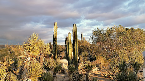
Photo
Where is located Valle de los Cirios
Valle de los Cirios — local attraction, which is located at Adolfo Ruiz Cortines 202 Poniente, Marcelo Rubio Ruiz, 23940 Guerrero Negro, B.C.S., Mexico and belongs to the category — national reserve. Average visitor rating for this place — 4.6 (according to 739 ratings, information from open sources and relevant for 2022).
Exact location — Valle de los Cirios, marked on the map with a red marker.
You can get directions to Valle de los Cirios on the map from your location.
What else is interesting in Guerrero Negro? You can see all the sights if you go to the city page.
Coordinates
Valle de los Cirios, Mexico coordinates in decimal format: latitude — 27.95681479125566, longitude — -114.00819972715233. When converted to degrees, minutes, seconds Valle de los Cirios has the following coordinates: 27°57′24.53 north latitude and -114°0′29.52 east longitude.
Nearby cities
The largest cities that are located nearby:
- Guaymas — 309 km
- Hermosillo — 324 km
- Ciudad Obregón — 408 km
- Navojoa — 465 km
- Nogales
 (United States) — 476 km
 - Ensenada — 493 km
- San Luis Río Colorado — 501 km
- Mexicali — 532 km
- Tucson (United States) — 555 km
- Los Mochis — 559 km
- La Paz — 566 km
- Tijuana — 575 km
- Chula Vista (United States) — 589 km
- San Diego (United States) — 600 km
- Chandler (United States) — 626 km
- Gilbert (United States) — 632 km
- Phoenix (United States) — 634 km
- Tempe (United States) — 635 km
- Escondido (United States) — 636 km
Distance to the capital
Distance to the capital (Mexico City) is about — 1785 km.