
 Bel-Ha
San Jose El Alto
El Porvenir
Nueva Palestina
Santa Lucía
Chemax
La Morita
Temoac
Zacualpan
Bel-Ha
San Jose El Alto
El Porvenir
Nueva Palestina
Santa Lucía
Chemax
La Morita
Temoac
Zacualpan
Cerro del Cubilete on the map, Silao, Mexico
Photo
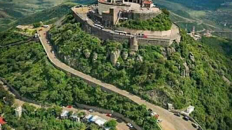
Where is located Cerro del Cubilete
Cerro del Cubilete — local attraction, which is located at 2,700 m and belongs to the category — -. Average visitor rating for this place — 4.7 (according to 1291 rating, information from open sources and relevant for 2022).
Exact location — Cerro del Cubilete, marked on the map with a red marker.
You can get directions to Cerro del Cubilete on the map from your location.
What else is interesting in Silao? You can see all the sights if you go to the city page.
Coordinates
Cerro del Cubilete, Mexico coordinates in decimal format: latitude — 20.960050000949217, longitude — -101.4161553755191. When converted to degrees, minutes, seconds Cerro del Cubilete has the following coordinates: 20°57′36.18 north latitude and -101°24′58.16 east longitude.
Nearby cities
The largest cities that are located nearby:
- Irapuato — 31 km
- León — 33 km
- Salamanca — 49 km
- Celaya — 79 km
- Santiago de Querétaro — 115 km
- Aguascalientes — 136 km
- Zamora — 139 km
- Morelia — 140 km
- San Luis Potosi — 141 km
- Soledad de Graciano Sánchez — 145 km
- San Juan del Río — 162 km
- Uruapan — 183 km
- Tonalá — 191 km
- Tlaquepaque — 198 km
- Guadalajara — 201 km
- Zapopan — 208 km
- Zacatecas — 233 km
- Toluca — 261 km
- Metepec — 268 km
Distance to the capital
Distance to the capital (Mexico City) is about — 293 km.