 Bel-Ha
San Jose El Alto
El Porvenir
Nueva Palestina
Santa Lucía
Chemax
La Morita
Temoac
Zacualpan
Bel-Ha
San Jose El Alto
El Porvenir
Nueva Palestina
Santa Lucía
Chemax
La Morita
Temoac
Zacualpan
Parque Xochipilli II on the map, Monclova, Mexico
Photo
Where is located Parque Xochipilli II
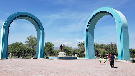
Parque Xochipilli II — local attraction, which is located at Sur 1115, Guerrero Ampliación, 25740 Monclova, Coah., Mexico and belongs to the category — park. Average visitor rating for this place — 4.7 (according to 2188 ratings, information from open sources and relevant for 2022).
Exact location — Parque Xochipilli II, marked on the map with a red marker.
You can get directions to Parque Xochipilli II on the map from your location.
What else is interesting in Monclova? You can see all the sights if you go to the city page.
Coordinates
Parque Xochipilli II, Mexico coordinates in decimal format: latitude — 26.8999490273499, longitude — -101.40630217540588. When converted to degrees, minutes, seconds Parque Xochipilli II has the following coordinates: 26°53′59.82 north latitude and -101°24′22.69 east longitude.
Nearby cities
The largest cities that are located nearby:
- General Escobedo — 166 km
- Santa Catarina — 167 km
- Saltillo — 169 km
- San Nicolas de los Garza — 171 km
- San Pedro Garza García — 172 km
- Monterrey — 174 km
- Apodaca — 175 km
- Guadalupe — 179 km
- Nuevo Laredo — 194 km
- Laredo
 (United States) — 202 km
 - Piedras Negras — 216 km
- Matamoros — 236 km
- Torreón — 249 km
- Gómez Palacio — 252 km
- Ciudad Acuna — 271 km
- Reynosa — 325 km
- McAllen (United States) — 326 km
- San Antonio (United States) — 396 km
- Brownsville (United States) — 406 km
Distance to the capital
Distance to the capital (Mexico City) is about — 862 km.