
 Bel-Ha
San Jose El Alto
El Porvenir
Nueva Palestina
Santa Lucía
Chemax
La Morita
Temoac
Zacualpan
Bel-Ha
San Jose El Alto
El Porvenir
Nueva Palestina
Santa Lucía
Chemax
La Morita
Temoac
Zacualpan
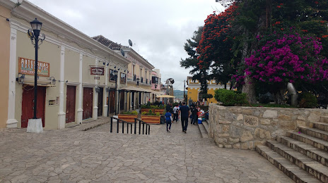
Benito Juárez Central Park on the map, Comitan, Mexico
Photo
Where is located Benito Juárez Central Park
Benito Juárez Central Park — local attraction, which is located at Central Poniente, Tercera Calle Sur Pte., Centro, 30000 Comitán de Domínguez, Chis., Mexico and belongs to the category — park. Average visitor rating for this place — 4.6 (according to 7568 ratings, information from open sources and relevant for 2022).
Exact location — Benito Juárez Central Park, marked on the map with a red marker.
You can get directions to Benito Juárez Central Park on the map from your location.
What else is interesting in Comitan? You can see all the sights if you go to the city page.
Coordinates
Benito Juárez Central Park, Mexico coordinates in decimal format: latitude — 16.25225453832734, longitude — -92.13550977558968. When converted to degrees, minutes, seconds Benito Juárez Central Park has the following coordinates: 16°15′8.12 north latitude and -92°8′7.84 east longitude.
Nearby cities
The largest cities that are located nearby:
- San Cristóbal de las Casas — 77 km
- Tuxtla Gutiérrez — 118 km
- Tapachula — 149 km
- Quetzaltenango
 (Guatemala) — 169 km
 - Villahermosa — 212 km
- San Juan Sacatepéquez (Guatemala) — 231 km
- Guatemala City (Guatemala) — 248 km
- Villa Nueva (Guatemala) — 251 km
- Escuintla (Guatemala) — 258 km
- Villa Canales (Guatemala) — 261 km
- Ciudad del Carmen — 268 km
- Minatitlán — 320 km
- Coatzacoalcos — 322 km
- Santa Ana
 (El Salvador) — 372 km
 - Apopa (El Salvador) — 415 km
- Santa Tecla (El Salvador) — 416 km
- Mejicanos (El Salvador) — 418 km
- San Salvador (El Salvador) — 421 km
- Soyapango (El Salvador) — 426 km
Distance to the capital
Distance to the capital (Mexico City) is about — 821 km.