 Warner Robins
Wantagh
Bethel
Misty Hill Farm
United States
Wakonda Beach (R33) Airport
Wilmington
Poland
Miami International Airport
Warner Robins
Wantagh
Bethel
Misty Hill Farm
United States
Wakonda Beach (R33) Airport
Wilmington
Poland
Miami International Airport
Medlock Bridge Chattahoochee River National Recreation Area on the map, Johns Creek, United States
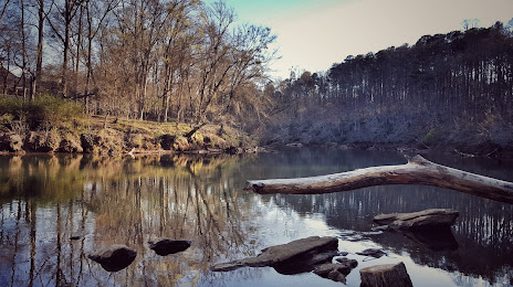
Photo
Where is located Medlock Bridge Chattahoochee River National Recreation Area
Medlock Bridge Chattahoochee River National Recreation Area — local attraction, which is located at Medlock Bridge Rd, Duluth, GA 30097, United States and belongs to the category — park. Average visitor rating for this place — 4.6 (according to 213 ratings, information from open sources and relevant for 2022).
Exact location — Medlock Bridge Chattahoochee River National Recreation Area, marked on the map with a red marker.
You can get directions to Medlock Bridge Chattahoochee River National Recreation Area on the map from your location.
What else is interesting in Johns Creek? You can see all the sights if you go to the city page.
Coordinates
Medlock Bridge Chattahoochee River National Recreation Area, United States coordinates in decimal format: latitude — 33.9941697521481, longitude — -84.20402437523705. When converted to degrees, minutes, seconds Medlock Bridge Chattahoochee River National Recreation Area has the following coordinates: 33°59′39.01 north latitude and -84°12′14.49 east longitude.
Nearby cities
The largest cities that are located nearby:
- Atlanta — 36 km
- Chattanooga — 151 km
- Knoxville — 215 km
- Huntsville — 230 km
- Birmingham — 247 km
- Montgomery — 269 km
- Columbia — 290 km
- Nashville — 330 km
- Charlotte — 331 km
- Savannah — 361 km
- Clarksville — 394 km
- Tallahassee — 397 km
- Charleston — 420 km
- Winston-Salem — 421 km
- Greensboro — 454 km
- Jacksonville — 475 km
- Louisville — 486 km
- Fayetteville — 495 km
- Gainesville — 516 km
Distance to the capital
Distance to the capital (Washington) is about — 842 km.