 Warner Robins
Wantagh
Bethel
Misty Hill Farm
United States
Wakonda Beach (R33) Airport
Wilmington
Poland
Miami International Airport
Warner Robins
Wantagh
Bethel
Misty Hill Farm
United States
Wakonda Beach (R33) Airport
Wilmington
Poland
Miami International Airport
Lowell-Dracut-Tyngsborough State Forest on the map, Dracut, United States
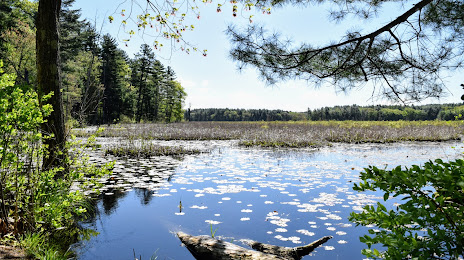
Photo
Where is located Lowell-Dracut-Tyngsborough State Forest
Lowell-Dracut-Tyngsborough State Forest — local attraction, which is located at Trotting Park Rd, Lowell, MA 01854, United States and belongs to the category — state park. Average visitor rating for this place — 4.5 (according to 384 ratings, information from open sources and relevant for 2022).
Exact location — Lowell-Dracut-Tyngsborough State Forest, marked on the map with a red marker.
You can get directions to Lowell-Dracut-Tyngsborough State Forest on the map from your location.
What else is interesting in Dracut? You can see all the sights if you go to the city page.
Coordinates
Lowell-Dracut-Tyngsborough State Forest, United States coordinates in decimal format: latitude — 42.656348072742595, longitude — -71.37079337498484. When converted to degrees, minutes, seconds Lowell-Dracut-Tyngsborough State Forest has the following coordinates: 42°39′22.85 north latitude and -71°22′14.86 east longitude.
Nearby cities
The largest cities that are located nearby:
- Lowell — 4 km
- Cambridge — 36 km
- Manchester — 38 km
- Boston — 40 km
- Worcester — 61 km
- Providence — 94 km
- Amherst — 104 km
- Springfield — 123 km
- Hartford — 152 km
- Waterbury — 190 km
- New Haven — 202 km
- Bridgeport — 227 km
- Stamford — 258 km
- Yonkers — 290 km
- Sherbrooke
 (Canada) — 305 km
 - Paterson — 308 km
- New York — 313 km
- Brooklyn — 314 km
- Newark — 322 km
Distance to the capital
Distance to the capital (Washington) is about — 633 km.