
 Bel-Ha
San Jose El Alto
El Porvenir
Nueva Palestina
Santa Lucía
Chemax
La Morita
Temoac
Zacualpan
Bel-Ha
San Jose El Alto
El Porvenir
Nueva Palestina
Santa Lucía
Chemax
La Morita
Temoac
Zacualpan
Cerro del Venado on the map, San Andres Tuxtla, Mexico
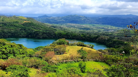
Photo
Where is located Cerro del Venado
Cerro del Venado — local attraction, which is located at 95814 San Andrés Tuxtla, Veracruz, Mexico and belongs to the category — theme park. Average visitor rating for this place — 4.3 (according to 61 rating, information from open sources and relevant for 2022).
Exact location — Cerro del Venado, marked on the map with a red marker.
You can get directions to Cerro del Venado on the map from your location.
What else is interesting in San Andres Tuxtla? You can see all the sights if you go to the city page.
Coordinates
Cerro del Venado, Mexico coordinates in decimal format: latitude — 18.464892893229624, longitude — -95.19515927555867. When converted to degrees, minutes, seconds Cerro del Venado has the following coordinates: 18°27′53.61 north latitude and -95°11′42.57 east longitude.
Nearby cities
The largest cities that are located nearby:
- Coatzacoalcos — 86 km
- Minatitlán — 86 km
- Córdoba — 185 km
- Orizaba — 203 km
- Xalapa — 215 km
- Oaxaca — 221 km
- Tehuacán — 229 km
- Villahermosa — 243 km
- Martínez de la Torre — 262 km
- Tuxtla Gutiérrez — 291 km
- Puebla — 320 km
- Poza Rica de Hidalgo — 328 km
- San Cristóbal de las Casas — 332 km
- Ciudad del Carmen — 357 km
- Tulancingo — 374 km
- Cuautla — 394 km
- Ixtapaluca — 394 km
- Chalco de Díaz Covarrubias — 395 km
- Texcoco — 400 km
Distance to the capital
Distance to the capital (Mexico City) is about — 428 km.