
 Bel-Ha
San Jose El Alto
El Porvenir
Nueva Palestina
Santa Lucía
Chemax
La Morita
Temoac
Zacualpan
Bel-Ha
San Jose El Alto
El Porvenir
Nueva Palestina
Santa Lucía
Chemax
La Morita
Temoac
Zacualpan
Balneario Romavec on the map, Ciudad Altamirano, Mexico
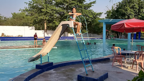
Photo
Where is located Balneario Romavec
Balneario Romavec — local attraction, which is located at 61992 Vicente Riva Palacio, Michoacán, Mexico and belongs to the category — water park. Average visitor rating for this place — 3.9 (according to 306 ratings, information from open sources and relevant for 2022).
Exact location — Balneario Romavec, marked on the map with a red marker.
You can get directions to Balneario Romavec on the map from your location.
What else is interesting in Ciudad Altamirano? You can see all the sights if you go to the city page.
Coordinates
Balneario Romavec, Mexico coordinates in decimal format: latitude — 18.356923358358603, longitude — -100.66567173290159. When converted to degrees, minutes, seconds Balneario Romavec has the following coordinates: 18°21′24.92 north latitude and -100°39′56.42 east longitude.
Nearby cities
The largest cities that are located nearby:
- Iguala — 119 km
- Toluca — 147 km
- Metepec — 149 km
- Chilpancingo — 152 km
- Morelia — 159 km
- Cuernavaca — 164 km
- Jiutepec — 166 km
- Uruapan — 184 km
- Acapulco — 185 km
- Cuautla — 186 km
- Naucalpan — 195 km
- Ciudad López Mateos — 197 km
- Tlalnepantla — 202 km
- Cuautitlán Izcalli — 206 km
- Buenavista — 208 km
- Ciudad Nezahualcóyotl — 210 km
- Chalco de Díaz Covarrubias — 210 km
- Ixtapaluca — 214 km
- Chimalhuacan — 214 km
Distance to the capital
Distance to the capital (Mexico City) is about — 201 km.