 Warner Robins
Wantagh
Bethel
Misty Hill Farm
United States
Wakonda Beach (R33) Airport
Wilmington
Poland
Miami International Airport
Warner Robins
Wantagh
Bethel
Misty Hill Farm
United States
Wakonda Beach (R33) Airport
Wilmington
Poland
Miami International Airport
Spring Rock Park on the map, Western Springs, United States
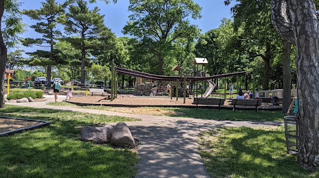
Photo
Where is located Spring Rock Park
Spring Rock Park — local attraction, which is located at 4400 Central Ave, Western Springs, IL 60558, United States and belongs to the category — park. Average visitor rating for this place — 4.7 (according to 233 ratings, information from open sources and relevant for 2022).
Exact location — Spring Rock Park, marked on the map with a red marker.
You can get directions to Spring Rock Park on the map from your location.
What else is interesting in Western Springs? You can see all the sights if you go to the city page.
Coordinates
Spring Rock Park, United States coordinates in decimal format: latitude — 41.8066863915903, longitude — -87.90614287501171. When converted to degrees, minutes, seconds Spring Rock Park has the following coordinates: 41°48′24.07 north latitude and -87°54′22.11 east longitude.
Nearby cities
The largest cities that are located nearby:
- Naperville — 22 km
- Chicago — 24 km
- Joliet — 35 km
- Aurora — 35 km
- Rockford — 110 km
- Milwaukee — 136 km
- South Bend — 137 km
- Madison — 185 km
- Peoria — 188 km
- Grand Rapids — 221 km
- Fort Wayne — 244 km
- Indianapolis — 270 km
- Lansing — 290 km
- Green Bay — 300 km
- Ann Arbor — 344 km
- Toledo — 359 km
- Flint — 366 km
- Detroit — 401 km
- Windsor
 (Canada) — 402 km
Distance to the capital
Distance to the capital (Washington) is about — 975 km.