
 Itoshima
Saikai
Izumi
Ichikikushikino
Uruma
Kirishima
Kunisaki
Bungotakada
Gotsu
Itoshima
Saikai
Izumi
Ichikikushikino
Uruma
Kirishima
Kunisaki
Bungotakada
Gotsu
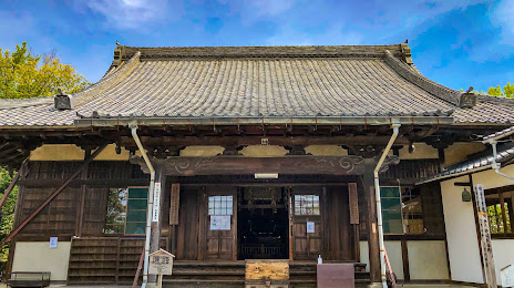
Muryōju-ji Temple on the map, Chiryu, Japan
Photo
Where is located Muryōju-ji Temple
Muryōju-ji Temple — local attraction, which is located at Jinai-61-1 Yatsuhashicho, Chiryu, Aichi 472-0001, Japan and belongs to the category — buddhist temple. Average visitor rating for this place — 3.8 (according to 203 ratings, information from open sources and relevant for 2022).
Exact location — Muryōju-ji Temple, marked on the map with a red marker.
You can get directions to Muryōju-ji Temple on the map from your location.
What else is interesting in Chiryu? You can see all the sights if you go to the city page.
Coordinates
Muryōju-ji Temple, Japan coordinates in decimal format: latitude — 35.00718263537311, longitude — 137.07576892478988. When converted to degrees, minutes, seconds Muryōju-ji Temple has the following coordinates: 35°0′25.86 north latitude and 137°4′32.77 east longitude.
Nearby cities
The largest cities that are located nearby:
- Kariya — 5 km
- Anjo — 5 km
- Okazaki — 12 km
- Toyota — 13 km
- Nishio — 15 km
- Handa — 16 km
- Nagoya — 24 km
- Seto — 25 km
- Kasugai — 28 km
- Kuwana — 34 km
- Komaki — 34 km
- Toyokawa — 35 km
- Inazawa — 37 km
- Tajimi — 37 km
- Yokkaichi — 39 km
- Toyohashi — 40 km
- Ichinomiya — 40 km
- Suzuka — 44 km
- Kakamigahara — 48 km