
 Itoshima
Saikai
Izumi
Ichikikushikino
Uruma
Kirishima
Kunisaki
Bungotakada
Gotsu
Itoshima
Saikai
Izumi
Ichikikushikino
Uruma
Kirishima
Kunisaki
Bungotakada
Gotsu
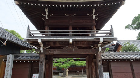
Ryoun Temple on the map, Chiryu, Japan
Photo
Where is located Ryoun Temple
Ryoun Temple — local attraction, which is located at Nishi-84-1 Nishimachi, Chiryu, Aichi 472-0023, Japan and belongs to the category — buddhist temple. Average visitor rating for this place — 3.9 (according to 14 ratings, information from open sources and relevant for 2022).
Exact location — Ryoun Temple, marked on the map with a red marker.
You can get directions to Ryoun Temple on the map from your location.
What else is interesting in Chiryu? You can see all the sights if you go to the city page.
Coordinates
Ryoun Temple, Japan coordinates in decimal format: latitude — 35.01020043683116, longitude — 137.04087762479008. When converted to degrees, minutes, seconds Ryoun Temple has the following coordinates: 35°0′36.72 north latitude and 137°2′27.16 east longitude.
Nearby cities
The largest cities that are located nearby:
- Kariya — 5 km
- Anjo — 5 km
- Okazaki — 12 km
- Toyota — 13 km
- Nishio — 15 km
- Handa — 16 km
- Nagoya — 24 km
- Seto — 25 km
- Kasugai — 28 km
- Kuwana — 34 km
- Komaki — 34 km
- Toyokawa — 35 km
- Inazawa — 37 km
- Tajimi — 37 km
- Yokkaichi — 39 km
- Toyohashi — 40 km
- Ichinomiya — 40 km
- Suzuka — 44 km
- Kakamigahara — 48 km