Mortka — Zvannoye
Mortka — Primorsk
Mortka — Svinovo
Mortka — Kamsko-Ustyinsky District
Mortka — Pobedinka
Mortka — Zolotovka
Mortka — Energetik
Mortka — Troitskoye
Mortka — Novodugino
Mortka — Baklushi
Mortka — Kamyshino
Mortka — Davydkovo
Mortka — Chumikan
Mortka — Serpukhov-15
Mortka — Afrikanda
Mortka — Torbeevo
Mortka — Udino
Mortka — Trubchevsk
Mortka — Belogostitsy
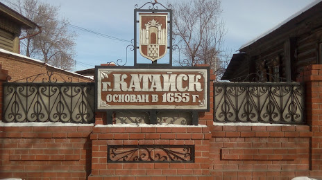
Mortka — Kataysk distance, route on the map
Distance by car
Distance between Mortka, Khanty-Mansi Autonomous Okrug, Russian Federation and Kataysk, Kurgan Oblast, Russian Federation by car is — km, or miles. To travel this distance by car, you need minute, or h.
Route on the map, driving directions
Car route Mortka — Kataysk was created automatically. The road on the map is shown as a blue line. By moving the markers, you can create a new route through the points you need.
Distance by plane
If you decide to take a trip Mortka Kataysk by plane, then you have to fly the distance — 395 km or 245 miles. It is marked on the map with a gray line (between two points in a straight line).
Flight time
Estimated flight time Mortka Kataysk by plane at cruising speed 750 km / h will be — 31 min.
Direction of movement
Russian Federation, Mortka — right-hand traffic. Russian Federation, Kataysk — right-hand traffic.
Difference in time
Mortka and Kataysk are in the same time zone. Between them there is no time difference (UTC +5 Asia/Yekaterinburg).
Interesting Facts
Information on alternative ways to get to your destination.
The length of this distance is about 1.0% of the total length of the equator.
The percentage of the population is clearly shown in the graph:
Mortka — 3,698 (less by 11,922), Kataysk — 15,620 residents.
The cost of travel
Calculate the cost of the trip yourself using the fuel consumption calculator, changing the data in the table.