
 Puerto de la Duquesa
La Serna de Iguña
Pumalverde
Puentenansa
La Iglesia
Casar de Periedo
Fuengirola
Renedo de Piélagos
Villabanez
Puerto de la Duquesa
La Serna de Iguña
Pumalverde
Puentenansa
La Iglesia
Casar de Periedo
Fuengirola
Renedo de Piélagos
Villabanez
Paseo Fluvial de Arteixo on the map, Arteixo, Spain
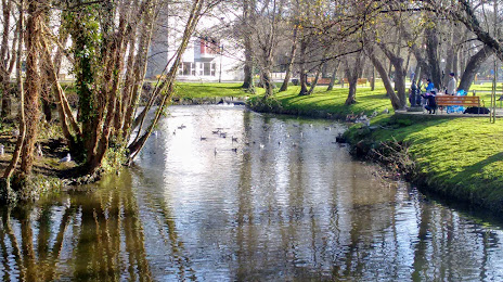
Photo
Where is located Paseo Fluvial de Arteixo
Paseo Fluvial de Arteixo — local attraction, which is located at Av. del Balneario, 21, 15690 Arteixo, A Coruña, Spain and belongs to the category — park. Average visitor rating for this place — 4.3 (according to 19 ratings, information from open sources and relevant for 2022).
Exact location — Paseo Fluvial de Arteixo, marked on the map with a red marker.
You can get directions to Paseo Fluvial de Arteixo on the map from your location.
What else is interesting in Arteixo? You can see all the sights if you go to the city page.
Coordinates
Paseo Fluvial de Arteixo, Spain coordinates in decimal format: latitude — 43.30370614459176, longitude — -8.506989474964126. When converted to degrees, minutes, seconds Paseo Fluvial de Arteixo has the following coordinates: 43°18′13.34 north latitude and -8°30′25.16 east longitude.
Nearby cities
The largest cities that are located nearby:
- A Coruña — 10 km
- Vigo — 119 km
- Ourense — 119 km
- Braga
 (Portugal) — 195 km
 - Oviedo — 214 km
- Gijón — 230 km
- Porto (Portugal) — 237 km
- León — 252 km
- Coimbra (Portugal) — 343 km
- Salamanca — 351 km
- Valladolid — 362 km
- Santander — 378 km
- Burgos — 407 km
- Bilbao — 449 km
- Vitoria-Gasteiz — 475 km
- Logroño — 503 km
- Amadora (Portugal) — 506 km
- Queluz (Portugal) — 507 km
- Badajoz — 507 km
Distance to the capital
Distance to the capital (Madrid) is about — 511 km.