
 Puerto de la Duquesa
La Serna de Iguña
Pumalverde
Puentenansa
La Iglesia
Casar de Periedo
Fuengirola
Renedo de Piélagos
Villabanez
Puerto de la Duquesa
La Serna de Iguña
Pumalverde
Puentenansa
La Iglesia
Casar de Periedo
Fuengirola
Renedo de Piélagos
Villabanez
Vía verde del Aceite on the map, Martos, Spain
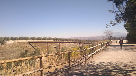
Photo
Where is located Vía verde del Aceite
Vía verde del Aceite — local attraction, which is located at P.º de la Estación, 69, 23640 Torre del Campo, Jaén, Spain and belongs to the category — hiking area. Average visitor rating for this place — 4.5 (according to 426 ratings, information from open sources and relevant for 2022).
Exact location — Vía verde del Aceite, marked on the map with a red marker.
You can get directions to Vía verde del Aceite on the map from your location.
What else is interesting in Martos? You can see all the sights if you go to the city page.
Coordinates
Vía verde del Aceite, Spain coordinates in decimal format: latitude — 37.746166701594305, longitude — -3.945665562385097. When converted to degrees, minutes, seconds Vía verde del Aceite has the following coordinates: 37°44′46.2 north latitude and -3°56′44.4 east longitude.
Nearby cities
The largest cities that are located nearby:
- Jaén — 18 km
- Granada — 68 km
- Córdoba — 73 km
- Málaga — 117 km
- Marbella — 156 km
- Almería — 165 km
- Dos Hermanas — 178 km
- Algeciras — 219 km
- Jerez — 223 km
- Albacete — 230 km
- Cádiz — 244 km
- Murcia — 249 km
- Cartagena — 261 km
- Huelva — 267 km
- Tetouan
 (Morocco) — 269 km
 - Tangier (Morocco) — 274 km
- Fuenlabrada — 285 km
- Getafe — 287 km
- Móstoles — 288 km
Distance to the capital
Distance to the capital (Madrid) is about — 298 km.