
 Puerto de la Duquesa
La Serna de Iguña
Pumalverde
Puentenansa
La Iglesia
Casar de Periedo
Fuengirola
Renedo de Piélagos
Villabanez
Puerto de la Duquesa
La Serna de Iguña
Pumalverde
Puentenansa
La Iglesia
Casar de Periedo
Fuengirola
Renedo de Piélagos
Villabanez
Stampida on the map, Vila-seca, Spain
Photo
Where is located Stampida
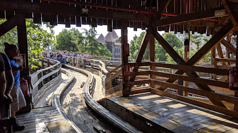
Stampida — local attraction, which is located at Av. Pere Molas, km 2, 43840, Tarragona, Spain and belongs to the category — roller coaster. Average visitor rating for this place — 4.5 (according to 3719 ratings, information from open sources and relevant for 2022).
Exact location — Stampida, marked on the map with a red marker.
You can get directions to Stampida on the map from your location.
What else is interesting in Vila-seca? You can see all the sights if you go to the city page.
Coordinates
Stampida, Spain coordinates in decimal format: latitude — 41.100090241581405, longitude — 1.1544376255492628. When converted to degrees, minutes, seconds Stampida has the following coordinates: 41°6′0.32 north latitude and 1°9′15.98 east longitude.
Nearby cities
The largest cities that are located nearby:
- Tarragona — 8 km
- Lleida — 71 km
- L'Hospitalet de Llobregat — 85 km
- Terrassa — 87 km
- Sabadell — 93 km
- Santa Coloma de Gramenet — 96 km
- Badalona — 98 km
- Mataró — 118 km
- Zaragoza — 178 km
- Palma — 213 km
- Valencia — 223 km
- Perpignan
 (France) — 225 km
 - Toulouse (France) — 277 km
- Pamplona — 295 km
- Logroño — 329 km
- Albacete — 348 km
- San Sebastián — 351 km
- Montpellier (France) — 353 km
- Vitoria-Gasteiz — 366 km
Distance to the capital
Distance to the capital (Madrid) is about — 416 km.