
 Puerto de la Duquesa
La Serna de Iguña
Pumalverde
Puentenansa
La Iglesia
Casar de Periedo
Fuengirola
Renedo de Piélagos
Villabanez
Puerto de la Duquesa
La Serna de Iguña
Pumalverde
Puentenansa
La Iglesia
Casar de Periedo
Fuengirola
Renedo de Piélagos
Villabanez
Castillo de Villanueva de Jamuz on the map, La Bañeza, Spain
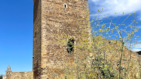
Photo
Where is located Castillo de Villanueva de Jamuz
Castillo de Villanueva de Jamuz — local attraction, which is located at C. Carretera, 38, 24762 Villanueva de Jamuz, León, Spain and belongs to the category — castle. Average visitor rating for this place — 4.3 (according to 115 ratings, information from open sources and relevant for 2022).
Exact location — Castillo de Villanueva de Jamuz, marked on the map with a red marker.
You can get directions to Castillo de Villanueva de Jamuz on the map from your location.
What else is interesting in La Bañeza? You can see all the sights if you go to the city page.
Coordinates
Castillo de Villanueva de Jamuz, Spain coordinates in decimal format: latitude — 42.23277773189526, longitude — -5.858797474998287. When converted to degrees, minutes, seconds Castillo de Villanueva de Jamuz has the following coordinates: 42°13′58 north latitude and -5°51′31.67 east longitude.
Nearby cities
The largest cities that are located nearby:
- León — 43 km
- Oviedo — 117 km
- Valladolid — 120 km
- Gijón — 138 km
- Salamanca — 148 km
- Ourense — 161 km
- Burgos — 180 km
- Santander — 211 km
- Braga
 (Portugal) — 225 km
 - Vigo — 231 km
- A Coruña — 234 km
- Porto (Portugal) — 260 km
- Bilbao — 261 km
- Vitoria-Gasteiz — 268 km
- Alcobendas — 272 km
- Móstoles — 278 km
- Alcorcón — 278 km
- Leganés — 282 km
- Logroño — 282 km
Distance to the capital
Distance to the capital (Madrid) is about — 271 km.