
 Zelfana
Balloul
أحمد سالم كركرة
Ouargla Province
Boumaiza
Constantine
Frane
Ain Arko
Corso
Zelfana
Balloul
أحمد سالم كركرة
Ouargla Province
Boumaiza
Constantine
Frane
Ain Arko
Corso
المتحف العمومي الوطني - تبسة on the map, Tebessa, Algeria
Photo
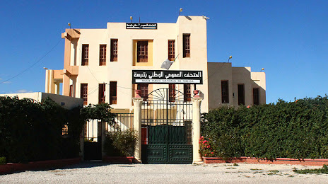
Where is located المتحف العمومي الوطني - تبسة
المتحف العمومي الوطني - تبسة — local attraction, which is located at C4C8+7Q5, Tebessa, Algeria and belongs to the category — museum. Average visitor rating for this place — 3.9 (according to 7 ratings, information from open sources and relevant for 2022).
Exact location — المتحف العمومي الوطني - تبسة, marked on the map with a red marker.
You can get directions to المتحف العمومي الوطني - تبسة on the map from your location.
What else is interesting in Tebessa? You can see all the sights if you go to the city page.
Coordinates
المتحف العمومي الوطني - تبسة, Algeria coordinates in decimal format: latitude — 35.420601836148734, longitude — 8.11690672480104. When converted to degrees, minutes, seconds المتحف العمومي الوطني - تبسة has the following coordinates: 35°25′14.17 north latitude and 8°7′0.86 east longitude.
Nearby cities
The largest cities that are located nearby:
- Souk Ahras — 99 km
- Guelma — 131 km
- Annaba — 169 km
- Constantine — 171 km
- Batna — 176 km
- Skikda — 195 km
- Sousse
 (Tunisia) — 228 km
 - Tunis (Tunisia) — 240 km
- Gabes (Tunisia) — 249 km
- Sfax (Tunisia) — 252 km
- El Oued — 253 km
- Setif — 257 km
- Bizerte (Tunisia) — 257 km
- Bou Arreridj Bordj — 309 km
- Bejaia — 309 km
- Djerba Midoun (Tunisia) — 311 km
- M'Sila — 323 km
- Cagliari
 (Italy) — 431 km
 - Ouargla — 463 km