
 Puerto de la Duquesa
La Serna de Iguña
Pumalverde
Puentenansa
La Iglesia
Casar de Periedo
Fuengirola
Renedo de Piélagos
Villabanez
Puerto de la Duquesa
La Serna de Iguña
Pumalverde
Puentenansa
La Iglesia
Casar de Periedo
Fuengirola
Renedo de Piélagos
Villabanez
Parque del Agua Luis Buñuel on the map, Utebo, Spain
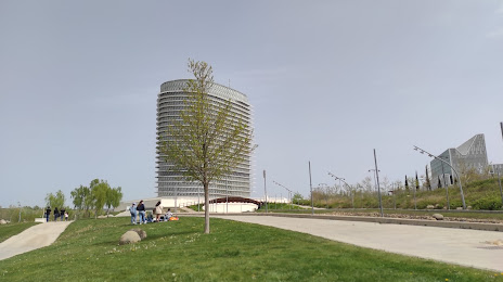
Photo
Where is located Parque del Agua Luis Buñuel
Parque del Agua Luis Buñuel — local attraction, which is located at P.º de los Puentes, 2, 50018 Zaragoza, Spain and belongs to the category — park. Average visitor rating for this place — 4.5 (according to 3095 ratings, information from open sources and relevant for 2022).
Exact location — Parque del Agua Luis Buñuel, marked on the map with a red marker.
You can get directions to Parque del Agua Luis Buñuel on the map from your location.
What else is interesting in Utebo? You can see all the sights if you go to the city page.
Coordinates
Parque del Agua Luis Buñuel, Spain coordinates in decimal format: latitude — 41.66923281449496, longitude — -0.912490275015985. When converted to degrees, minutes, seconds Parque del Agua Luis Buñuel has the following coordinates: 41°40′9.24 north latitude and -0°54′44.96 east longitude.
Nearby cities
The largest cities that are located nearby:
- Zaragoza — 11 km
- Pamplona — 133 km
- Lleida — 134 km
- Logroño — 144 km
- Vitoria-Gasteiz — 187 km
- San Sebastián — 195 km
- Tarragona — 198 km
- Burgos — 231 km
- Bilbao — 232 km
- Alcala de Henares — 241 km
- Terrassa — 249 km
- Torrejón de Ardoz — 250 km
- Valencia — 253 km
- Alcobendas — 257 km
- Sabadell — 258 km
- L'Hospitalet de Llobregat — 261 km
- Santa Coloma de Gramenet — 268 km
- Badalona — 270 km
- Getafe — 278 km
Distance to the capital
Distance to the capital (Madrid) is about — 272 km.