
 Puerto de la Duquesa
La Serna de Iguña
Pumalverde
Puentenansa
La Iglesia
Casar de Periedo
Fuengirola
Renedo de Piélagos
Villabanez
Puerto de la Duquesa
La Serna de Iguña
Pumalverde
Puentenansa
La Iglesia
Casar de Periedo
Fuengirola
Renedo de Piélagos
Villabanez
Laguna del Prado on the map, Miguelturra, Spain
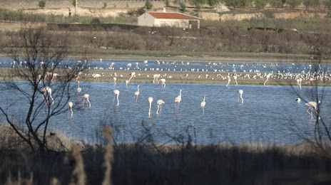
Photo
Where is located Laguna del Prado
Laguna del Prado — local attraction, which is located at Ciudad Real and belongs to the category — -. Average visitor rating for this place — 4.2 (according to 14 ratings, information from open sources and relevant for 2022).
Exact location — Laguna del Prado, marked on the map with a red marker.
You can get directions to Laguna del Prado on the map from your location.
What else is interesting in Miguelturra? You can see all the sights if you go to the city page.
Coordinates
Laguna del Prado, Spain coordinates in decimal format: latitude — 39.00956544793965, longitude — -3.9442585085794013. When converted to degrees, minutes, seconds Laguna del Prado has the following coordinates: 39°0′34.44 north latitude and -3°56′39.33 east longitude.
Nearby cities
The largest cities that are located nearby:
- Jaén — 131 km
- Córdoba — 142 km
- Fuenlabrada — 147 km
- Getafe — 149 km
- Móstoles — 150 km
- Leganés — 152 km
- Alcorcón — 153 km
- Torrejón de Ardoz — 169 km
- Alcala de Henares — 174 km
- Albacete — 174 km
- Alcobendas — 175 km
- Granada — 199 km
- Málaga — 252 km
- Dos Hermanas — 258 km
- Murcia — 263 km
- Badajoz — 265 km
- Salamanca — 267 km
- Almería — 267 km
- Marbella — 285 km
Distance to the capital
Distance to the capital (Madrid) is about — 158 km.