
 Maureville
Samoëns
Gréning
Toulouse
Volx
Goudet
Méhoncourt
Saint-Hymer
Pontcarré
Maureville
Samoëns
Gréning
Toulouse
Volx
Goudet
Méhoncourt
Saint-Hymer
Pontcarré
Parc de l'Ovalie on the map, Saint-Égrève, France
Photo
Where is located Parc de l'Ovalie
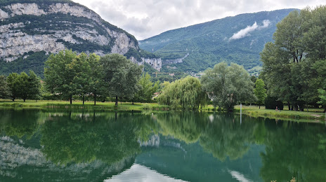
Parc de l'Ovalie — local attraction, which is located at Rue Pierre de Coubertin, 38360 Sassenage, France and belongs to the category — city park. Average visitor rating for this place — 4.4 (according to 525 ratings, information from open sources and relevant for 2022).
Exact location — Parc de l'Ovalie, marked on the map with a red marker.
You can get directions to Parc de l'Ovalie on the map from your location.
What else is interesting in Saint-Égrève? You can see all the sights if you go to the city page.
Coordinates
Parc de l'Ovalie, France coordinates in decimal format: latitude — 45.23363296761974, longitude — 5.667495846528912. When converted to degrees, minutes, seconds Parc de l'Ovalie has the following coordinates: 45°14′1.08 north latitude and 5°40′2.99 east longitude.
Nearby cities
The largest cities that are located nearby:
- Grenoble — 6 km
- Villeurbanne — 85 km
- Lyon — 88 km
- Saint-Étienne — 103 km
- Geneva
 (Switzerland) — 112 km
 - Turin
 (Italy) — 158 km
 - Lausanne (Switzerland) — 160 km
- Nimes — 187 km
- Aix-en-Provence — 189 km
- Clermont-Ferrand — 209 km
- Nice — 210 km
- Marseille — 216 km
- Besançon — 223 km
- Novara (Italy) — 229 km
- Montpellier — 230 km
- Bern (Switzerland) — 232 km
- Toulon — 234 km
- Dijon — 236 km
- Milan (Italy) — 273 km
Distance to the capital
Distance to the capital (Paris) is about — 475 km.