
 Belém
Maranguape
Paranaguá
Paranaguá
Monte Alegre
Alvorada de Minas
Bragança
Laguna
Ibiporã
Belém
Maranguape
Paranaguá
Paranaguá
Monte Alegre
Alvorada de Minas
Bragança
Laguna
Ibiporã
Rotunda Ribeirão Vermelho on the map, Lavras, Brazil
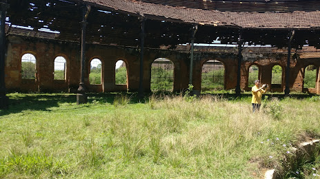
Photo
Where is located Rotunda Ribeirão Vermelho
Rotunda Ribeirão Vermelho — local attraction, which is located at Ribeirão Vermelho - State of Minas Gerais, 37264-000, Brazil and belongs to the category — monument. Average visitor rating for this place — 4.4 (according to 399 ratings, information from open sources and relevant for 2022).
Exact location — Rotunda Ribeirão Vermelho, marked on the map with a red marker.
You can get directions to Rotunda Ribeirão Vermelho on the map from your location.
What else is interesting in Lavras? You can see all the sights if you go to the city page.
Coordinates
Rotunda Ribeirão Vermelho, Brazil coordinates in decimal format: latitude — -21.177403023125954, longitude — -45.06817936864286. When converted to degrees, minutes, seconds Rotunda Ribeirão Vermelho has the following coordinates: -21°10′38.65 north latitude and -45°4′5.45 east longitude.
Nearby cities
The largest cities that are located nearby:
- Divinópolis — 123 km
- Barbacena — 127 km
- Resende — 146 km
- Betim — 164 km
- Barra Mansa — 166 km
- Ibirité — 167 km
- Volta Redonda — 167 km
- Poços de Caldas — 171 km
- Guaratinguetá — 174 km
- Contagem — 176 km
- Juiz de Fora — 179 km
- Esmeraldas — 181 km
- Belo Horizonte — 184 km
- Ribeirão das Neves — 190 km
- Pindamonhangaba — 191 km
- Sabará — 194 km
- Santa Luzia — 196 km
- Taubaté — 204 km
- Angra dos Reis — 206 km