
 Maureville
Samoëns
Gréning
Toulouse
Volx
Goudet
Méhoncourt
Saint-Hymer
Pontcarré
Maureville
Samoëns
Gréning
Toulouse
Volx
Goudet
Méhoncourt
Saint-Hymer
Pontcarré
Plage du Lac on the map, Le Bouscat, France
Photo
Where is located Plage du Lac
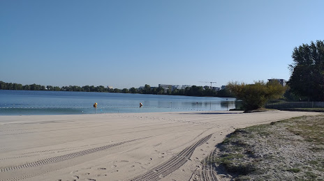
Plage du Lac — local attraction, which is located at Bd Jacques Chaban-Delmas, 33520 Bruges, France and belongs to the category — public beach. Average visitor rating for this place — 3.9 (according to 2285 ratings, information from open sources and relevant for 2022).
Exact location — Plage du Lac, marked on the map with a red marker.
You can get directions to Plage du Lac on the map from your location.
What else is interesting in Le Bouscat? You can see all the sights if you go to the city page.
Coordinates
Plage du Lac, France coordinates in decimal format: latitude — 44.87813026635112, longitude — -0.5789386750072326. When converted to degrees, minutes, seconds Plage du Lac has the following coordinates: 44°52′41.27 north latitude and -0°34′44.18 east longitude.
Nearby cities
The largest cities that are located nearby:
- Bordeaux — 3 km
- Limoges — 179 km
- San Sebastián
 (Spain) — 204 km
 - Toulouse — 215 km
- Pamplona (Spain) — 242 km
- Bilbao (Spain) — 258 km
- Nantes — 270 km
- Vitoria-Gasteiz (Spain) — 279 km
- Angers — 289 km
- Tours — 296 km
- Santander (Spain) — 301 km
- Clermont-Ferrand — 302 km
- Logroño (Spain) — 305 km
- Le Mans — 352 km
- Zaragoza (Spain) — 356 km
- Rennes — 368 km
- Perpignan — 372 km
- Lleida (Spain) — 373 km
- Burgos (Spain) — 377 km
Distance to the capital
Distance to the capital (Paris) is about — 495 km.